


Lovewell Reservoir
Map of Lovewell Reservoir


Click here for a Google Earth map of Lovewell
Click here to download a map of Lovewell
Lovewell Wildlife Area has 2,215 acres of public hunting area available around the reservoir. Lovewell Dam impounds approximately 3,000 surface acres of water and is situated on White Rock Creek. Lovewell is an irrigation reservoir with seasonally changing water levels. Expect lower water levels in the late summer through winter months but the reservoir is refilled annually by diverting water from the Republican River at Guide Rock, Nebraska into a canal that empties into the northeast corner of the reservoir. This area is small and receives heavy hunting and fishing pressure.
Species managed for include deer, turkey, waterfowl and upland game like pheasant, quail, rabbit and squirrel. Management will focus on increasing the quality of the experience for visitors by managing wildlife and habitats with an ecological based approach as the primary goal. The limited public lands in Kansas require intensive wildlife management and some special restrictions will be used to provide quality hunting and fishing areas.
INLET CANAL CLOSED TO FISHING SEPTEMBER 15 THROUGH APRIL 15.
NEW REFUGE REGULATIONS:THE LAND REFUGE CLOSED TO HUNTING YEAR ROUND. CLOSED TO OTHER ACTIVITIES YEARROUND. WATER REFUGE IN EFFECT NOVEMBER 1 THROUGH APRIL 15 on the NORTHEAST half of the reservoir and Wildlife Area from 1/8th mile west of the south end of the dam and following a buoy line northwest to the western boundary of the Cabin Area. No hunting from the park shoreline.
You can follow the reservoir water levels by going to this website, http://www.usbr.gov/gp-bin/arcweb_lvks.pl
Lovewell and Jamestown Wildlife Areas
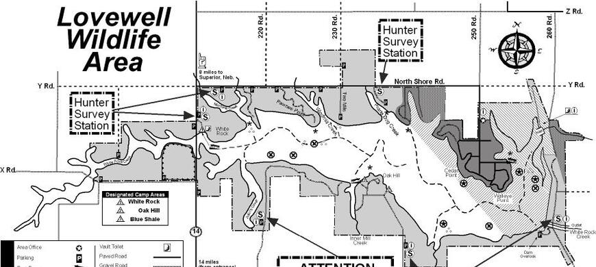
The only place to obtain the paper Hunter Survey Cards are at the Lovewell Office at the entrance to Lovewell State Park at 2446 250 Rd or at the Jamestown Wildlife Area Headquarters at 299 Marsh Trail.
Hunters are encouraged to register your hunting activity electronically here, https://ksoutdoors.com/checkin using your licensing login credentials. Please register prior to arriving on the property as mobile phone and internet service is sketchy. FREE wi-fi is available in front of the Lovewell Office.
IF YOU STILL NEED TO USE THE PAPER PERMITS, they will still be available at the Lovewell Office where permits can be obtained prior to hunting and dropped off with needed information after hunting. The survey station location is just west of the Lovewell Office, under the concrete shelter where a brown, metal self user survey station has been placed to dispense permits and provide for collection. As in the past, prior to the day’s hunt, hunters will need to pick up a permit, fill out the top portion and place it in the designated box, and carry the bottom portion of the permit with them while on the area hunting. When the hunt is finished, the bottom portion of the permit needs to be returned to the survey station with completed information on the day’s hunt. Hunter participation and cooperation is critical to the success of this study.
Persons wanting additional information or questions should contact the Hays Regional Office at 785-628-8614 or the specific area they plan to hunt. Lovewell (785) 753-4971. Jamestown (785) 439-6243.
Special Hunts and Refuge Areas are in effect September 1 - April 1.
Camping is only allowed in designated areas as a companion activity to hunting and fishing.
Horses are restricted to maintained roads and are not allowed off roads.
ATV/UTV's are prohibited anywhere on the area.
A permit to access a designated ADA vehicle access area is available from the manager to persons meeting the requirements.
Here is a complete list of Public Land Regulations or you can download the regulation summary.
The 4,625 acre Lovewell Wildlife Area was made available to the Kansas Forestry Fish and Game Commission under terms of a lease agreement with the Department of Interior in 1959 after the completion in 1957 of Lovewell Reservoir, a 3,000 acre flood control and irrigation reservoir. In 1972, 200 acres were purchased by the Kansas Fish and Game Commission and is owned by the state of Kansas. Lands previously managed by the Kansas Park Authority that were transferred to KFG now bring the total area leased from the Bureau of Reclamation under wildlife management to 5,215 acres.
- Type of Facility: Parking
- Location of Facility: 39.883701 -98.028359
- Click for more information
- Type of Facility: Boat Ramp
- This facility is ADA accessible
- Location of Facility: 39.894353 -98.074166
- Click for more information
- Type of Facility: Information Center
- Location of Facility: 39.887948 -98.101985
- Click for more information
- Type of Facility: Boat Ramp
- This facility is ADA accessible
- Location of Facility: 39.905462 -98.115361
- Click for more information
- Type of Facility: Parking
- Location of Facility: 39.909385 -98.105366
- Click for more information
- Type of Facility: Parking
- Location of Facility: 39.906907 -98.088333
- Click for more information
- Type of Facility: Parking
- Location of Facility: 39.907469 -98.080463
- Click for more information
- Type of Facility: Parking
- Location of Facility: 39.911082 -98.070839
- Click for more information
- Type of Facility: Fishing Area
- This facility is ADA accessible
- Location of Facility: 39.906000 -98.022811
- Click for more information
| Waterfowl numbers | Most waterfowl including light geese numbers have decreased significantly but numbers fluctuate daily. Waterfowl have already moved north as they push to the snowline which is just north of the South Dakota/Nebraska border. . ATTENTION - NUMBERS OF LIGHT GEESE HAVE DIED FROM HPAI. USE EXTREME CAUTION WITH HANDLING THESE BIRDS (SEE COMMENTS BELOW) |
| Mallard Migration Ranking | |
| Water level | Lovewell Reservoir is at 157963 or 2.97 feet below Conservation Pool,( 73.9% full). The BOR and Kansas Bostwick Irrigation District are releasing 0.2 cfs. Inflows of 27.5 cfs from the Guide Rock Diversion Canal from the Republican River is being used to refill the reservoir aand these inflows have restarted. The construction project on the canal is completed. Irrigation season ended on 9/16. |
| Hunting condition | 100% OPEN WATER. ZERO ICE COVERAGE LOVEWELL RESERVOIR HAS NO WATCHES OR WARNINGS FOR HARMFUL ALGAE BLOOMS. USERS SHOULD STILL BE ON THE LOOKOUT FOR POCKETS OF HARMFUL ALGAE BLOOMS. Mudflats are ringing the entire reservoir and the water is a away from the normal shorelinE. Japanese millet was seeded. There is sparse concealing vegetation close to the water. ALL BOAT RAMPS ARE OPEN AND USEABEL EXCEPT THE WHITE ROCK CREEK AREA WHICH OPENS ON APRIL 16 ALL BOATS ARE REQUIRED TO USE NAVIGATION LIGHTS WHILE OPERATING BETWEEN THE HOURS OF SUNSET AND SUNRISE. PFD'S MUST NOT BE STOWED IN ANY COMPARTMENT WHILE THE BOAT IS UNDER POWER. KEEP THEM OUT OR BETTER YET ...ON! NON-MOTORIZED BOAT NEED SOME FLASHLIGHT OR LANTERN. |
| Expected hunting success | VERY POOR ON THE WILDLIFE AREA AND PRIVATE LAND. POOR HUNTING ON PRIVATE LANDS IN THE AREA. OBTAIN PERMISSION FROM ALL PRIVATE LANDOWNERS BEFORE HUNTING ON ANY OF THEIR PROPERTY OPEN SEASONS - ONLY THE CONSERVATION SEASON FOR LIGHT GOOSE IS OPEN |
| Comments | DEAD AND DYING LIGHT GEESES ARE PRESENT ON THE SHORELINES. CONTACT WITH THESE BIRDS SHOULD BE AVOIDED. RESULTS FROM TESTING HAVE BEEN RECEIVED. IT IS ILLEGAL TO HANDLE THESE DEAD BIRDS. CONTACT WITH THE DRIED ALGAE AND POCKETS OF VISIBLE ALGAE BLOOM AREAS IS NOT RECOMMENDED AND SHOULD BE AVOIDED, ESPECIALLY FOR DOGS. PARK PERMIT REQUIRED TO ENTER THE STATE PARK. NO HUNTING IS ALLOWED FROM THE SHORELINE OF THE STATE PARK. REFUGE REGULATIONS: The land refuge closed to hunting and other activities year-round. Water refuge in effect November 1 through April 15 on the NORTHEAST half of the reservoir and Wildlife Area from 1/8th mile west of the south end of the dam and following a buoy line northwest to the western boundary of the Cabin Area of the State Park. This area open to fishing south and east of the buoy line from the north end of the dam to the Lovewell State Park Twin Coves trailer area. Inlet canal closed to fishing September 15 through April 15. BOAT RAMPS: SEE HUNTING CONDITION FOR BOAT RAMP STATUS. The State Park boat ramps require a Kansas State Park Permit. The Wildlife Area Boat Ramps are Pawnee Point, Oak Hill and White Rock Creek do not require a permit. CAMPING CABINS are available in Lovewell State Park. Make reservations HERE HUNTERS ARE ENCOURAGED TO :
FOLLOWING SAFE AND ETHICAL PRACTICES WILL ENSURE THAT EVERYONE HUNTING PUBLIC LANDS ENJOYS A HIGH-QUALITY EXPERIENCE. Hunters can check-in / check-out here, https://license.gooutdoorskansas.com using your licensing login credentials. Contact the office for other arrangements. We thank you for your patience. Please introduce youth and novice hunters to the outdoors. Pass it on! |