


Cheyenne Bottoms Wildlife Area


THE OFFICIAL WEBSITE OF KANSAS WILDLIFE, PARKS AND TOURISM, CHEYENNE BOTTOMS WILDLIFE AREA
24 hr current conditions Phone: 620-793-7730

Area Office Phone: 620-793-3066
Area Wildlife Manager: Jason Wagner
Hunters can check-in / check-out here, https://ksoutdoors.com/checkin using your licensing login credentials.
From Great Bend, KS:
- 5 miles North on US Highway 281.
- 2 miles East
From Hoisington, KS:
- 5 miles South on US Highway 281.
- 2 miles East
From Highway K-4:
- You can access Cheyenne Bottoms by turning South at Redwing and following the gravel road.
From Highway K-156
- You can also access Cheyenne Bottoms from K-156
Area News
8/4/2023
All of the major construction projects have wrapped up. Dirt work has started on the Goose Pens. It should have only minimal impact on the management of the area. A water control structure will need to be replaced on the inlet canal that will briefly interrupt water diversions. Once complete, it will add an additional 100 acres of usable wetland to the property that will be used for Special Hunts for youth.
Silt removal continues in the inlet canal and along the ditches in Pool 2 to help get water into the West Hub for the new pump station. All of the old foot bridges to access pools 2, 3A, 3B, and 4A have been replaced. An additional 9 more foot bridges were added, for a total of 14 to help with hunter access. All blind islands have been rebuilt in pools 3A, 3B, 4A, and 4B. A few islands have also been rebuilt in the eastern portion of Pool 2. The islands should provide good cover for hunters to hide and allow them to space out better. The islands also provide excellent loafing and nesting areas for birds. The drought also helped with cattail control. Over the last 6 years, staff have worked to clear over 5,000 acres of cattails on the property. This has vastly improved habitat conditions and usable space on the property not only for waterfowl, but also all water birds like shorebirds.
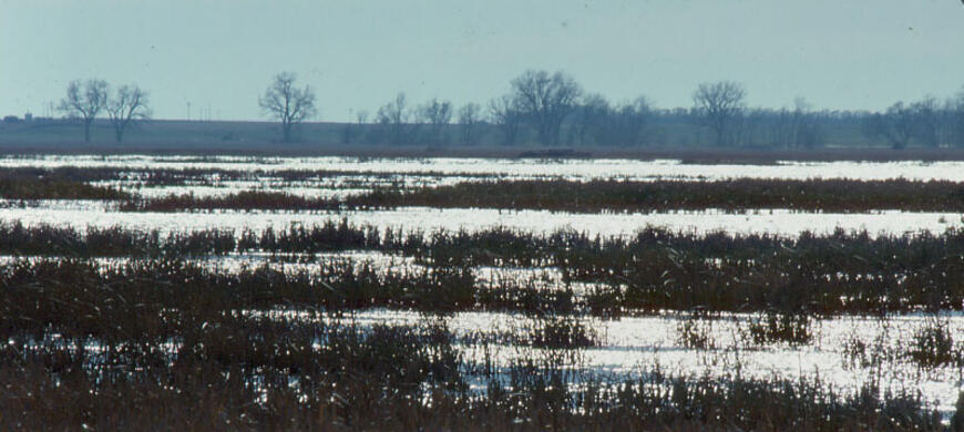
Significant rains have finally fell this spring. However, it has done little to ease the dry conditions at the Bottoms since the drought was so severe across central and western Kansas. Water was available in the Wet Walnut, and it was diverted into Pool 1A. With the lack of soil moisture, it took a lot of water to saturate the ground. Hot conditions late in summer evaporated the majority of water on the property. Only 8" of water remains in Pool 1A, which isn't enough to put any amount of water on any perimeter pool.. The rest of the pools have only held water briefly after a rain. Habitat conditions in the pools are pretty good if there is water available to flood. Although the rains failed to fill the Bottoms, they have fallen in the right locations to prime the landscape for future runoff events. It is still going to take some very significant rains to fill the Bottoms.
Visit the Kansas Wetlands Education Center at Cheyenne Bottoms. They have educational exhibits directed at describing the role wetlands play in the natural world with a focus on Cheyenne Bottoms. Find out the wide variety of wetlands found in Kansas, you may be surprised at the diversity in this grassland state. Their location is in the southeast portion of Cheyenne Bottoms Wildlife Area along Kansas Highway 156. Their hours are Monday through Saturday 9 to 5, Sunday 1 to 5. They are closed Mondays from November 1 through March 31. The phone number is 620-566-1456.
Here are some helpful documents and articles for your trip Cheyenne Bottoms.
THE OFFICIAL WEBSITE OF KANSAS WILDLIFE, PARKS AND TOURISM, CHEYENNE BOTTOMS WILDLIFE AREA
24 hr current conditions Phone: 620-793-7730
Area Office Phone: 620-793-3066
Area Wildlife Manager: Jason Wagner
Hunters can check-in / check-out here, https://ksoutdoors.com/checkin using your licensing login credentials.
From Great Bend, KS:
- 5 miles North on US Highway 281.
- 2 miles East
From Hoisington, KS:
- 5 miles South on US Highway 281.
- 2 miles East
From Highway K-4:
- You can access Cheyenne Bottoms by turning South at Redwing and following the gravel road.
From Highway K-156
- You can also access Cheyenne Bottoms from K-156
- Vehicles are permitted only on established roads and parking areas. Driving off roads or on roads closed by sign or barrier is prohibited.
- Camping is permitted only in the primitive campground located 1/2 mile west of the area office.
- The use of watercraft is restricted to minimize disturbance to the wildlife and to ensure a more aesthetically pleasing experience for all visitors. Watercraft are not permitted in the refuge areas. During the waterfowl season, in-water propeller-driven boats and hand powered boats can be utilized in Pools 2, 3 and 4. Airboats are not allowed at any time. Outside the waterfowl season, only hand-powered boats are allowed. From April 15 to August 15, hand powered watercraft are not permitted between 10 A.M. and 5 P.M. Life jacket laws will be enforced.

Pool 2
- Littering is prohibited. Take all trash with you.
- Boats, decoys, ammunition, binoculars and other supplies are not available at the area office.
- The Mitigation Marsh, located in the southeast portion of the Wildlife Area, is managed as a youth hunting area. It is open to hunters less than 16 years old hunters accompanied by no more than two adults.
- Non-toxic shot is required for all shotgun hunting. The possession of lead shot in the field is prohibited.
- No shooting is allowed on or from the dikes.
- No holes or pits may be dug for any purpose. Portable blinds and temporary blinds made of native vegetation may be used but must be removed within 10 days after the close of the hunting season or after the last day of use.
Here is a complete list of Public Land Regulations or you can download the regulation summary.
The 19,857-acre Cheyenne Bottoms Wildlife Area is part of a 41,000-acre natural land sink just northeast of Great Bend.
During the 1940's and1950s, the State of Kansas acquired the land, and dikes were constructed to impound water in five pools. Canals and dams were built to divert water from the nearby Arkansas River and Wet Walnut Creek to supplement water provided by two intermittent streams, Blood and Deception creeks. Monies for this initial land purchasing and development came from two sources. One was the sale of hunting licenses. The second was from a Federal excise tax on sporting arms and ammunition. The Federal Aid in Wildlife Restoration Act was passed in 1937. This legislation allows for the collection of this excise tax money which is then apportioned out to each state with the amount received based on the total area of the state and the number of hunting licenses sold. The program is a cost reimbursement program where the state covers the full amount of an approved project then applies for reimbursement through Federal Aid for up to 75% of the project expenses. Cheyenne Bottoms was one of the first projects the State of Kansas embarked on using this Federal program. Federal Aid continues to fund, along with hunting license dollars, the annual operation and maintenance of the property for all to enjoy. Some of the best wildlife viewing opportunities can be had on land bought and maintained using these hunter generated dollars.
During the 1990s, extensive renovation sub-divided some of the pools. In addition, pump stations were built to allow for increased management flexibility and water level manipulation. This renovation effort also provided increased water conservation to better meet wildlife needs during dry periods. Manipulation of water levels in the pools is a major tool in managing the marsh for water birds. Another part of the renovation was the construction of large (2 to 5 acre) islands in Pools 3 and 4. These islands served as locations to deposit accumulated silt in areas of chronic cattail stands. They also are used by hunters and nesting birds.
Each year, one or more of the pools is drained as deemed necessary. Often these areas are seeded to millet and/or wheat and undesirable vegetation is controlled by burning, mowing and disking while the pools are dry. The photo below shows the current plant that is posing a threat to Cheyenne Bottoms. Phragmites is a wetland plant that, if left unchecked, can take over a marsh. It has even out competed cattail at Cheyenne Bottoms.

The History behind some of the parking lot names.
Several years ago names were given to the various parking lots located around the Wildlife Area. The effort was being done to get away from the institutionalized numbering system in place and to recognize some of the history associated with the Bottoms. Presented here are the names of the lots and the background behind them.
Coursing Club: During the late 1800’s and early 1900’s a Coursing Club was located a bit north and west of the Wildlife Area office about 1.5 miles. They used greyhounds to chase jack rabbits.
4 Corners: Located northeast of the office 2 miles, this lot is close to the lodge of an early 20th Century duck hunting club by that name.
Brinkman: Located 1 mile west and about 3 miles south of Redwing, this lot is named after an early landowner who settled in the northern portion of Cheyenne Bottoms in the 1870’s or 80’s.
Redwing: Named after the small community located to the north of the parking lot.
Kinzel: This lot, on the east side of Pool 3B, is named after a family residing in the area for some time.
Pike: Located on the east side of Pool 3B, this lot is named after the explorer who passed through the basin in 1806.
Schrepel: Located behind Pool 4A, this lot is named after the family that had a farm here in the early 1900's.
Deadman: Located behind Pool 4A, off K-156 Highway, this lot is named after an incident in the late 1900's when a person was discovered having apparently committed suicide near the lot.
White Rock: This lot is located on the south end of the Pool 4A/4B dividing dike. Following the renovation of the 1990’s, this parking lot was surfaced with crushed limestone rock giving it a white color.
Ridge Road: A military road from Fort Harker to Fort Larned crossed the basin in the mid to late 1800's. In periods of wet conditions travelers shifted their route to the south following a ‘ridge’ around the basin avoiding the water.
Green Lake: Prior to development as a wildlife area, several small depressions held water longer than the rest of the basin when going dry. Located north of this lot about 1 ¼ miles, on the east end of the Goose Hunting Zones, was Green Lake. It was one of these depressions.
Silo: This parking lot on the Goose Hunting Zones is named for the long standing landmark north of the lot.
Gunnery: During World War 2 the Army Air Corps used the Bottoms as a training/target area for plane crews flying out of the Great Bend Airfield. Located less than a mile west of this lot, on the west end of the Goose Hunting Zones, were gun emplacement structures used for small arms/machine gun practice.
- Type of Facility: Parking Lot
- Location of Facility: 38 26 04.7 98 42 04.0
- Type of Facility: Boat Ramp
- Location of Facility: 38 28 58.0 98 40 58.0
- Type of Facility: Boat Ramp
- Location of Facility: 38 27 49.5 98 37 39.5
- Type of Facility: Wildlife Observation
- Location of Facility: 38 26 56.3 98 38 15.1
- Click for more information
- Type of Facility: Office
- Location of Facility: 38 26 05.0 98 39 52.0
- Click for more information
- Type of Facility: Parking Lot
- Location of Facility: 38 26 05.0 98 38 45.5
- Click for more information
- Type of Facility: Parking Lot
- Location of Facility: 38 26 27.4 98 37 50.3
- Click for more information
- Type of Facility: Parking Lot
- Location of Facility: 38 26 45.7 98 37 06.2
- Click for more information
- Type of Facility: Parking Lot
- Location of Facility: 38 27 00.3 98 37 05.3
- Click for more information
- Type of Facility: Boat Ramp
- Location of Facility: 38 27 17.9 98 36 33.1
- Click for more information
- Type of Facility: Boat Ramp
- Location of Facility: 38 27 50.1 98 35 49.4
- Type of Facility: Boat Ramp
- Location of Facility: 38 28 47.3 98 35 42.2
- Type of Facility: Boat Ramp
- Location of Facility: 38 29 51.0 98 36 04.3
- Click for more information
- Type of Facility: Boat Ramp
- Location of Facility: 38 29 17.2 98 36 41.8
- Click for more information
- Type of Facility: Boat Ramp
- Location of Facility: 38 28 42.2 98 38 11.0
- Click for more information
- Type of Facility: Boat Ramp
- Location of Facility: 38 28 43.1 98 38 17.3
- Click for more information
- Type of Facility: Boat Ramp
- Location of Facility: 38 30 02.0 98 39 06.2
- Click for more information
- Type of Facility: Boat Ramp
- Location of Facility: 38 28 14.3 98 40 25.5
- Click for more information
- Type of Facility: Boat Ramp
- Location of Facility: 38 27 34.3 98 4042.1
- Click for more information
- Type of Facility: Parking Lot
- Location of Facility: 38 27 48.6 98 42 45.1
- Click for more information
- Type of Facility: Office
- This facility is ADA accessible
- Location of Facility: 38 26 57.5 98 44 13.9
- Click for more information
| Waterfowl numbers | Snow goose numbers are declining as spring migration progresses. Duck numbers are increasing. If the report has not been updated in a few days, please assume that conditions and bird numbers are the same as the last update. |
| Water level | Pool 1A-30", Pool 1B-some sheet water, Pool 1C-dry Pool 2-some sheet water Pool 3A-10", Pool 3B-dry, Pool 4A-dry, Pool 4B-dry, Pool 5-dry. Recent rains have put some sheet water in some of the pools, but will likely soak in. Diverting some water from the river. Cheyenne Bottoms has no ground water pumps to fill pools. |
| Hunting conditions | Pool 2- Planted 60 acres of wheat in the pool. A total of 996 acres of cattails and Phragmites were sprayed August 2023. Blind islands are being rebuilt. Pool 3B- 135 acres of wheat planted in the pool. 5 acres of milo planted. Pool 3A- 4A- 4B- 5- Habitat in the pools look fair with decent amounts of smartweed and barnyard grass along with other annuals scattered throughout. All blind islands in 3A, 3B, 4A, and 4B have been rebuilt. |
| Expected hunting success | Poor. Less flooded acres than last year. Been slow so far this season, but a few birds are being harvested. Ducks continue to stay in the refuge portion of the property during legal shooting hours. Most of the waterfowl are using private land that has sheet water in ag fields and not staying on the wildlife area. |
| Comments | ISPORTSMAN IS NO LONGER IN USE. HUNTERS CAN CHECK IN VIA THE GOOUTDOORSKS APP OR THE WEBSITE https://license.gooutdoorskansas.com/Event/WMASignIn.aspx ALL BOATS MUST BE OPERATED AT NO WAKE SPEEDS. REGARDLESS OF THE TIME OR SCENERIO, ALL BOATS MUST BE OPERATED AT NO WAKE SPEEDS 100% OF THE TIME, NO EXCEPTIONS. POOL 4A IS CLOSED AT 1 P.M. DAILY TO MOTORIZED BOATS. ANY BOAT WITH A MOTOR ON IT MUST BE OUT OF THE WATER AT 1 P.M. NO MOTORING OUT PRIOR TO 1 P.M. THEN ROWING OR DRAGGING BOAT BACK IN AFTER 1 P.M. 3A IS CLOSED TO MOTORIZED BOATS MOTORIZED BOATS ALLOWED ONLY DURING OPEN WATERFOWL SEASON. THIS MEANS NO SCOUTING FROM A MOTOR BOAT PRIOR TO SEASON. ALL WATERCRAFT ARE PROHIBITED FROM APRIL 15-AUGUST 15 TO PROTECT NESTING BIRDS ON THE WILDLIFE AREA. DURING THE YOUTH/VETERANS/MILITARY WEEKEND, POOL 4B IS DESIGNATED AS A YOUTH ONLY POOL. LEGAL SHOOTING HOURS ARE 30 MINUTES BEFORE SUNRISE TO SUNSET. UNLAWFUL TO SHOOT FROM ROADS OR DIKES ON THE WILDLIFE AREA. DO NOT PARK BLOCKING ROADS, GATES, BOAT RAMPS, FOOT CROSSINGS, ETC. DO NOT LAUNCH TRAILERED BOATS FROM DIKES OR FOOT CROSSINGS. ANY BOATS ON A TRAILER MUST USE DESIGNATED BOAT RAMPS. NO TRASH POLICY ON THE WILDLIFE AREA. CAMP IN DESIGNATED CAMPGROUND ONLY Use footcrossings in Pools 2, 3A, 3B, 4A, and 4B as the ditches have been cleaned out and are very deep. No Special Hunts for the 2023-2024 season due to dry conditions. For waterfowl season dates, Cheyenne Bottoms is in the Low Plains Early Zone. |
Hunting at Cheyenne Bottoms

Hunting pressure on the Bottoms can be heavy during waterfowl season, particularly on weekends.
Prior to hunting any species on Cheyenne Bottoms Wildlife Area, all hunters are required to check-in here, https://ksoutdoors.com/checkin using your licensing login credentials.
Pools 1, 5 and a portion of Pool 2 are refuge areas and closed to all activities. Exceptions to this occur for some special hunts. Check with wildlife area personnel for more information.
In addition to waterfowl, other game may be legally taken at Cheyenne Bottoms. Pheasant hunting is usually good. Snipe and rail hunting is good along the shallow marsh margins. Quail and deer are also present in fair numbers.
A handicapped accessible hunting/photo blind is available by reservation. Call the office for additional information and reservations.
In the event of whooping crane activity, the pool the birds are in is closed to all hunting and the goose hunting zones are closed to crane and light goose hunting.
Motorized boats are allowed only during an open waterfowl season. All boats must be operated at no wake speeds. Pool 3A is closed to motorized boats. Pool 4A is closed to motorized boats at 1 p.m.
Bird Watching

Single Canada Goose
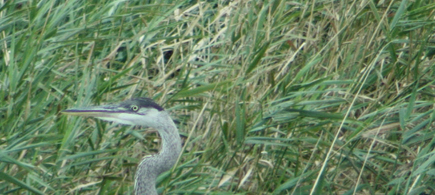
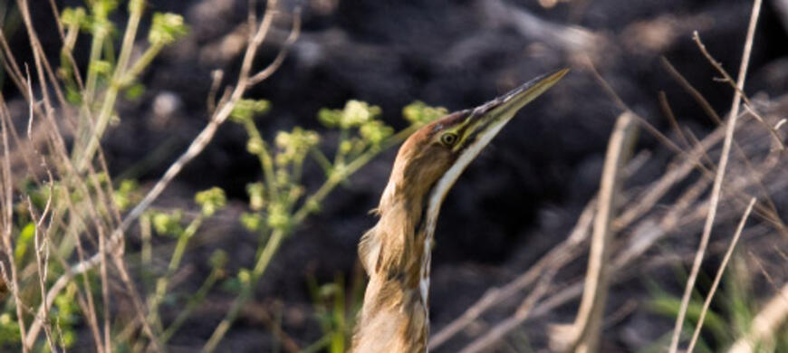
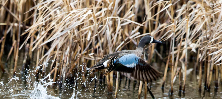
Because Cheyenne Bottoms is such a diverse, large and unique marsh, birdwatching is one of the more popular activities on the area. The spring and fall migration periods offer the best opportunity to view large numbers of different species in this one location. In spring, waterfowl and sandhill cranes can begin arriving as early as February. Wading birds, such as herons and egrets, begin arriving in March and April. Most shorebirds arrive in late April and early May. By late May, the birds that are still present on the area will tend to remain and nest.
The southward migration in fall can be a rewarding and challenging time for the birdwatcher. Most of the birds moving through the area during this time of year have replaced their breeding plumage with a set of feathers that lack much of the color they had just a few months earlier. This can make identification difficult, especially when looking at shorebirds. The fall shorebird migration can begin as early as July and extend well into September and October. Because of this, the bird numbers are not as impressive as the spring movement since the birds do not achieve as great a number at any one time. The peak period for duck viewing in the fall occurs early to mid-October. Most wading birds remain on the area until the marsh freezes. This is especially true for the great blue heron. Whooping cranes are most apt to stop at Cheyenne Bottoms in late October into early November. Bald eagles winter on the area and are present from as early as November to as late as March. A checklist of birds found on the area and the seasons they are present is available at the area office and the information signs at the main entrances. You may also download this list from this web page.
If you go to Interesting Facts, here on the Cheyenne Bottoms web page, you will find the nedian dates of first observation of many different species of birds. These observations are a compilation of data collected at Cheyenne Bottoms over the past 30 years.
For a current idea of birds present on the Area, go to Cheyenne Bottoms Wildlife Area News.
Other Activities
Fishing at Cheyenne Bottoms is limited, for the most part, to carp and bullheads. Occasional catches of channel cat, crappie and bass are made after several continuous years of having water on the area.
Trapping is permitted on the wildlife area. A special permit is required. It is available at the area office free of charge. However, trapping is not permitted at any time in the refuge area nor during the waterfowl season.
Click this link to view the current Cheyenne Bottoms Wildlife Area Newsletter. Click this link to sign up to receive the Cheyenne Bottoms Wildlife Area Newsletter via email.
MIGRATION PHENOLOGY
Median first observation date of birds with at least 5 observations at Cheyenne Bottoms during 1976-2003
| SPECIES | FEB | MAR | APR | MAY | JUN | JUL | AUG | SEP | OCT | NOV |
| Mallard | 4- Feb | |||||||||
| Common merganser | 4- Feb | |||||||||
| Hooded merganser | 6- Feb | |||||||||
| Belted kingfisher | 7- Feb | |||||||||
| Northern pintail | 8- Feb | |||||||||
| Common goldeneye | 9- Feb | |||||||||
| Greater white-fronted goose | 10- Feb | |||||||||
| Green-winged teal | 15- Feb | |||||||||
| Tundra swan | 16- Feb | |||||||||
| Sandhill crane | 17- Feb | |||||||||
| American wigeon | 19- Feb | |||||||||
| Redhead | 20- Feb | |||||||||
| Gadwall | 21- Feb | |||||||||
| American coot | 22- Feb | |||||||||
| Northern shoveler | 23- Feb | |||||||||
| Bufflehead | 23- Feb | |||||||||
| Snow goose | 24- Feb | |||||||||
| Lesser scaup | 27- Feb | |||||||||
| Canvasback | 28- Feb | |||||||||
| Ring-necked duck | 28- Feb | |||||||||
| Killdeer | 28- Feb | |||||||||
| Ruddy duck | 3- Mar | |||||||||
| Great blue heron | 8- Mar | |||||||||
| Cinnamon teal | 8- Mar | |||||||||
| Blue-winged teal | 9- Mar | |||||||||
| Pied-billed grebe | 10- Mar | |||||||||
| American white pelican | 16- Mar | |||||||||
| Wood duck | 16- Mar | |||||||||
| Greater yellowlegs | 19- Mar | |||||||||
| Baird's sandpiper | 19- Mar | |||||||||
| Long-billed dowitcher | 20- Mar | |||||||||
| Double-crested cormorant | 21- Mar | |||||||||
| Eastern phoebe | 23- Mar | |||||||||
| Lesser yellowlegs | 25- Mar | |||||||||
| Mourning dove | 25- Mar | |||||||||
| Common snipe | 26- Mar | |||||||||
| American avocet | 1- Apr | |||||||||
| Semipalmated sandpiper | 4- Apr | |||||||||
| Least sandpiper | 4- Apr | |||||||||
| Western sandpiper | 6- Apr | |||||||||
| Rough-winged swallow | 6- Apr | |||||||||
| Pectoral sandpiper | 7- Apr | |||||||||
| Eared grebe | 7- Apr | |||||||||
| American bittern | 8- Apr | |||||||||
| Turkey vulture | 8- Apr | |||||||||
| Black-crowned night-heron | 9- Apr | |||||||||
| Swainson's hawk | 9- Apr | |||||||||
| Yellow-headed blackbird | 9- Apr | |||||||||
| Great egret | 10- Apr | |||||||||
| Snowy egret | 10- Apr | |||||||||
| Snowy plover | 10- Apr | |||||||||
| Franklin's gull | 11- Apr | |||||||||
| Wilson's phalarope | 12- Apr | |||||||||
| Hudsonian godwit | 12- Apr | |||||||||
| Cattle egret | 12- Apr | |||||||||
| Black-necked stilt | 12- Apr | |||||||||
| Burrowing owl | 12- Apr | |||||||||
| Tree swallow | 12- Apr | |||||||||
| Long-billed curlew | 13- Apr | |||||||||
| White-faced ibis | 13- Apr | |||||||||
| Barn swallow | 13- Apr | |||||||||
| Marbled godwit | 14- Apr | |||||||||
| Forster's tern | 14- Apr | |||||||||
| Stilt sandpiper | 15- Apr | |||||||||
| Semipalmated plover | 16- Apr | |||||||||
| American golden-plover | 16- Apr | |||||||||
| Horned grebe | 16- Apr | |||||||||
| Little blue heron | 16- Apr | |||||||||
| Dunlin | 17- Apr | |||||||||
| Western grebe | 17- Apr | |||||||||
| Short-billed dowitcher | 18- Apr | |||||||||
| Osprey | 18- Apr | |||||||||
| Black-billed magpie | 19- Apr | |||||||||
| House wren | 19- Apr | |||||||||
| Willet | 20- Apr | |||||||||
| Whimbrel | 21- Apr | |||||||||
| Brown thrasher | 21- Apr | |||||||||
| Peregrine falcon | 23- Apr | |||||||||
| Common moorhen | 23- Apr | |||||||||
| Virginia rail | 24- Apr | |||||||||
| Sora | 24- Apr | |||||||||
| Cliff swallow | 24- Apr | |||||||||
| Piping plover | 25- Apr | |||||||||
| Spotted sandpiper | 26- Apr | |||||||||
| Upland sandpiper | 26- Apr | |||||||||
| Black-bellied plover | 27- Apr | |||||||||
| Western kingbird | 27- Apr | |||||||||
| Common yellowthroat | 27- Apr | |||||||||
| Eastern kingbird | 28- Apr | |||||||||
| Sanderling | 29- Apr | |||||||||
| Baltimore oriole | 30- Apr | |||||||||
| White-rumped sandpiper | 1- May | |||||||||
| Solitary sandpiper | 1- May | |||||||||
| Red knot | 2- May | |||||||||
| Buff-breasted sandpiper | 3- May | |||||||||
| Chimney swift | 3- May | |||||||||
| Green heron | 4- May | |||||||||
| Least bittern | 6- May | |||||||||
| Red-headed woodpecker | 7- May | |||||||||
| Gray catbird | 7- May | |||||||||
| Dickcissel | 8- May | |||||||||
| Ruddy turnstone | 9- May | |||||||||
| Red-necked phalarope | 9- May | |||||||||
| Mississippi kite | 9- May | |||||||||
| Black tern | 12- May | |||||||||
| Common nighthawk | 12- May | |||||||||
| Lesser yellowlegs | 2- Jul | |||||||||
| Semipalmated sandpiper | 8- Jul | |||||||||
| Marbled godwit | 8- Jul | |||||||||
| Western sandpiper | 9- Jul | |||||||||
| Greater yellowlegs | 10- Jul | |||||||||
| Long-billed dowitcher | 10- Jul | |||||||||
| Least sandpiper | 10- Jul | |||||||||
| Long-billed curlew | 12- Jul | |||||||||
| Stilt sandpiper | 12- Jul | |||||||||
| White-rumped sandpiper | 12- Jul | |||||||||
| Whimbrel | 13- Jul | |||||||||
| Willet | 17- Jul | |||||||||
| Baird's sandpiper | 18- Jul | |||||||||
| Short-billed dowitcher | 21- Jul | |||||||||
| Pectoral sandpiper | 23- Jul | |||||||||
| Solitary sandpiper | 23- Jul | |||||||||
| Semipalmated plover | 27- Jul | |||||||||
| Ruddy turnstone | 27- Jul | |||||||||
| Piping plover | 31- Jul | |||||||||
| Hudsonian godwit | 1- Aug | |||||||||
| Red knot | 7- Aug | |||||||||
| Sanderling | 8- Aug | |||||||||
| Black-bellied plover | 18- Aug | |||||||||
| Buff-breasted sandpiper | 22- Aug | |||||||||
| Common snipe | 6- Sep | |||||||||
| Dunlin | 8- Sep | |||||||||
| American golden-plover | 14- Sep | |||||||||
| Greater white-fronted goose | 24- Sep | |||||||||
| Sandhill crane | 1- Oct | |||||||||
| Whooping crane | 22- Oct | |||||||||
| Bald eagle | 19- Nov |