


Migratory Birds
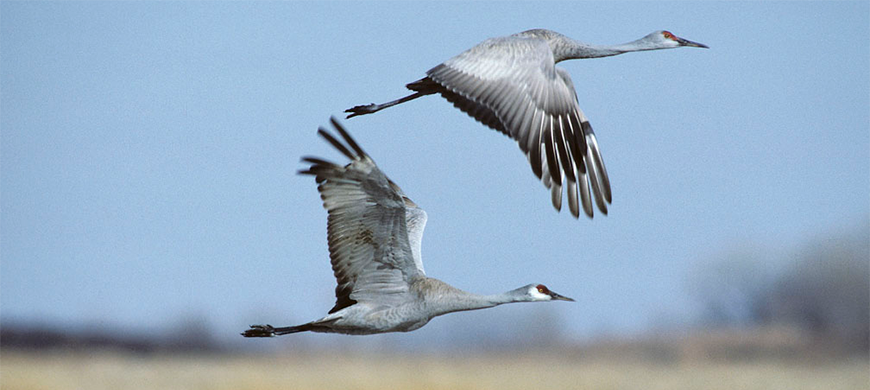


Shooting Hours: Shooting hours are one-half hour before sunrise to sunset for all migratory bird seasons, except sandhill crane.
Use the map below to pick a region you would like to look at Waterfowl Reports.

**Endangered whooping cranes have been observed in Northcentral and Northwest Kansas. Be cognizant of potential closures and restrictions, and as always, know your target before taking a shot. Shooting a whooping crane can carry fines up to $100,000 and/or up to one year in prison.**
**There have been outbreaks of disease among waterfowl in Northwest Kansas. While there appears to be low risk for human infection, domestic poultry and fowl are susceptible and extreme caution should be taken to reduce the risk of spreading disease. **
CEDAR BLUFF WILDLIFE AREA - Last Updated: 10/21/2024 Print
| 2-3000 Ducks - most dabbler species are present, a few divers. Waterfowl numbers changing daily. Approx. 300 Resident Cananda Geese No Hunting Allowed from the Dam *****REVIEW Kansas Boating Regulations if you are using a boat to hunt. ***** Refuge Boundaries are also displayed on OnX. NO ACCESS IN THE CLOSED PORTION OF THE LAND REFUGE SEPT. 1 - JAN. 31 NO ACCESS IN THE CLOSED PORTION OF THE WATER REFUGE NOV. 1 - JAN. 31 
| |
| Water level | Reservoir Elevation - 2122.9 - 21 ft. low |
| Hunting conditions | Mudflats at west end should attract some teal, very little flooded vegetation |
| Expected hunting success | Fair-low Lake levels will make concealment difficult and expect fall fishermen to be present. |
| Comments | Cedar Bluff Wildlife Mgmt. Area and Reservoir are in the Low Plains Late Duck Zone Contact Cedar Bluff Area Office 785-726-3212 for more information. Water Refuge is in effect November 1- January 31 Land Refuge is in effect September 1 - January 31 No Hunting Allowed from the Dam North Shore State Park is Closed to Hunting. Youth / Mentor hunting is also available. Zebra Mussels, Eurasian Milfoil, and Phragmites are present in Cedar Bluff Reservoir. Please clean and dry all equipment, decoys and boats before hunting other bodies of water. |
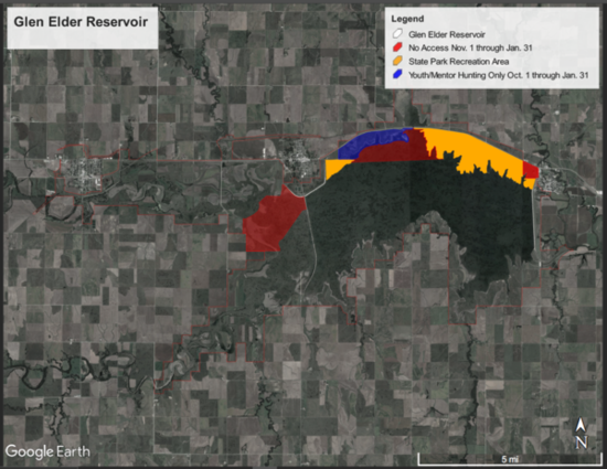
GLEN ELDER - Last Updated: 10/18/2024 Print
| Waterfowl numbers | ALL HUNTERS at Glen Elder WA are required to check-in AND check-out daily. Go to https://ksoutdoors.com/checkin or utilize the GoOutdoorsKS app and check-in using your licensing login credentials. It is YOUR responsibility to know a property's regulations, refuge(s) and duck zone boundaries, etc. BEFORE you hunt. Click here for a detailed map of the refuges, youth area, and State Park boundaries. Please be aware that the Low Plains Early Duck Zone and Low Plains Late Duck Zone boundary is HWY 24. This means Glen Elder WA North of Hwy 24 is in the Early Zone. The majority of the Glen Elder WA (South of HWY 24) is in the Late Zone. -- Finally have a respectable number of birds that are using the property. Estimating 1500-2000 ducks and 250-500 geese in the area currently. Numbers may change dramatically day-to-day. The water level in the lake remains very low and shorelines very muddy. Accessing the water from the shore may be challenging in spots. Some low lying areas around the lake have held water and may provide some hunting opportunity. --
|
| Water level | Lake is currently 6.5 feet below conservation (lowest level in 15+ years) and continuing to drop from evaporation. |
| Hunting conditions | Poor. Hunters still need to be cautious of DANGEROUS MUD CONDITIONS on the river areas. |
| Expected hunting success | Poor to fair. |
| Comments | Granite Creek boat ramp is closed seasonally from November 1 through January 31st. The following boat ramps are currently UNUSABLE due to low water levels: Granite Creek, North Fork River, Carr Creek, Schoen's Cove and Walnut Creek. Low Plains Early Duck Zone (North of Highway 24) season is OPEN until December 8, 2024. Then it will re-open from December 21, 2024 thru January 5, 2025. Low Plains Late Duck Zone (South of Highway 24) - Youth, Veteran, and Military season will be October 19 and 20, 2024. Regular season opens October 26, 2024. Dark geese season is CLOSED Whitefront season is CLOSED Light geese season is CLOSED. Cawker City and Granite Creek Refuge closure dates are November 1st - January 31st. The Youth/ Mentor hunting area is located in the Granite Creek Refuge and is in effect from October 1 - January 31. Waterfowl hunting from the shoreline area is allowed in the Youth-Mentor Area as long as EACH adult is hunting with a youth 17 years or younger. Boats of any sort are prohibited in the Granite Creek Refuge. Zebra Mussels have been confirmed in Waconda Lake. Be sure to dry boats and equipment before moving to other waters. |
JAMESTOWN WILDLIFE AREA - Last Updated: 10/16/2024 Print
| Waterfowl numbers | Waterfowl numbers remain low, even through this cold front. Pressure has kept them moving off of the area. REMEMBER: Hunters are REQUIRED to check-in / check-out here, https://ksoutdoors.com/checkin using your licensing login credentials. |
| Water levels | Water levels have decreased since teal season due to the hot, windy weather and almost no precipitation. We have missed out on a lot of the big rains recently, so water levels will be lower than last year. We are unable to move water into Marsh Creek Marsh or pump from Marsh Creek Marsh into Buffalo Creek Marsh due to water right restrictions. Puddler Marsh: Dry. Gamekeeper Marsh: We have gained some water in this marsh since Teal opener. Remember, the refuge is now closed; Gun Club West Marsh: Around half full; avg. depth of 12" to 14" Gun Club East: Same elevation as Gun Club West, avg. depth of 12" to 14" Greenwing Marsh; Huntable water with areas that were mowed prior to flooding. Marsh Creek Marsh: Dry due to water right restrictions Buffalo Creek Marshes: Dry due to water right restrictions Pintail Marsh: Dry |
| Hunting conditions | Excellent moist soil production and abundant flooded vegetation. Gun Club West has very high abundance of cattails that have been sprayed. Expect those to brown up and break down throughout the fall. Remember: NO ATV's are allowed on department lands and roads. THIS INCLUDES ARGO'S AND E-BIKES There is a no trash policy: If you take it in with you, please bring it out. This includes spent shotgun shells. THIS REGULATION WILL BE ENFORCED. ALL vehicles must remain on designated roads and parking areas. REFUGE IS CLOSED
|
| Expected hunting success | Poor. Hunting pressure was low for the opening weekend, however has been relatively high throughout the week. Especially with less huntable area than normal. Hunter have averaged just over two birds per hunter since Sunday. What birds that have stuck around have already become nocturnal and are leaving the area prior to shooting light. |
| Comments | As always, we need some rain. Good cold fronts will help. NO CAMPFIRES DUE TO THE EXTREMELY DRY CONDITIONS We had issues last season with reckless boating in the early morning hours. Please remember to be cautious while running the boat channels, as there is little to no room for more than one boat at a time. We have had several near collisions and mishaps. Also remember, ALL boating regulations will be enforced. Navigation lights (red and green bow lights along with an all around white stern light, light bars and headlamps do not qualify), life jackets, passenger capacities and boat registrations (even lay-out boats with a motor) ARE required. We have also had issues with hunters playing loud music while motoring out and setting up. Please remember to be courteous of other hunters on the area. Not everyone wants to hear it. The MANDATORY electronic check system can be found on the GoOutdoorsKS app. or by following the link below and using your licensing login credentials.
Waterfowl Seasons Low Plains Early Duck Season (First Segment): 10/12/24 - 12/8/24 Low Plains Early Duck Season (Second Segment): 12/21/24 - 1/5/25 Canada Geese: 10/26/24 - 10/27/24 and 11/6/24 - 2/16/25 White-Fronted Geese: 10/26/24 - 12/26/24 and 1/25/25 - 2/16/25 Light Geese: 10/26/24 - 10/27/24 and 11/6/24 - 2/16/25 Light Geese Conservation Order: 2/17/25 - 4/30/25 Hunters are REQUIRED to check in AND OUT using the electronic permitting system. Hunters need to check-in / check-out by going to https://ksoutdoors.com/checkin using your licensing login credentials. Hunters need to make sure they have all the appropriate licenses and stamps for hunting waterfowl. The following are required: Kansas hunting license State waterfowl stamp Federal waterfowl stamp Kansas Harvest Information Program Stamp (HIP) RINGNECK MARSH IS DESIGNATED FOR YOUTH AND MENTORS ONLY. EACH HUNTER 16 YEARS AND OLDER MUST BE ACCOMPANIED BY ONE OR MORE YOUTH UNDER 16 YEARS OLD. Marsh Creek Marsh and the West Gamekeeper Marsh is for non-gasoline powered boats or paddle-in / Walk-in only, this includes electric motor boats and boats with no motors. Gasoline engines are prohibited. Buffalo Creek & Pintail Marshes are for non-motorized boats and walk-in hunting only. HUNTERS ARE ENCOURAGED TO :
THE REFUGE IS OPEN Please introduce youth and novice hunters to the outdoors. Pass it on! |
LOVEWELL RESERVOIR - Last Updated: 10/18/2024 Print
| Waterfowl numbers | More waterfowl starting to show up. Teal, mallards, gadwalls, wood ducks and Canada geese. |
| Mallard Migration Ranking | |
| Water level | Lovewell Reservoir is at 1575.14 or 7.46 feet below Conservation Pool,( 45% full). The BOR and Kansas Bostwick Irrigation District are releasing 0.2 cfs. Inflows of 19.8 cfs from the Guide Rock Diversion Canal from the Republican River is being used to refill the reservoir. Irrigation season ended on 9/16. |
| Hunting condition | LOVEWELL RESERVOIR HAS NO WATCHES OR WARNINGS FOR HARMFUL ALGAE BLOOMS. USERS SHOULD STILL BE ON THE LOOKOUT FOR POCKETS OF HARMFUL ALGAE BLOOMS. CONTACT WITH THE DRIED ALGAE AND POCKETS OF VISIBLE ALGAE BLOOM AREAS IS NOT RECOMMENDED AND SHOULD BE AVOIDED, ESPECIALLY FOR DOGS. Mudflats are ringing the entire reservoir and the water is a away from the normal shorelinE. Japanese millet was seeded. There is sparse concealing vegetation close to the water. THE CEDAR POINT AND ONE LANE AT THE MARINA BOAT RAMP IN LOVEWELL STATE PARK ARE USEABLE AT THIS TIME. ALL OTHER BOAT RAMPS ARE NOT USEABLE. ALL BOATS ARE REQUIRED TO USE NAVIGATION LIGHTS WHILE OPERATING BETWEEN THE HOURS OF SUNSET AND SUNRISE. PFD'S MUST NOT BE STOWED IN ANY COMPARTMENT WHILE THE BOAT IS UNDER POWER. KEEP THEM OUT OR BETTER YET ...ON! NON-MOTORIZED BOAT NEED SOME FLASHLIGHT OR LANTERN. |
| Expected hunting success | FAIR TO GOOD ON THE WILDLIFE AREA. WATERFOWL ARE USING THE RESERVOIR TO ROOST. LATE LOW PLAINS ADA, YOUTH, VETERAN AND ACTIVE DUTY MILITARY SEASON OPEN STATURDAY AND SUNDAY, 10/19 - 20. |
| Comments | PARK PERMIT REQUIRED TO ENTER THE STATE PARK. NO HUNTING IS ALLOWED FROM THE SHORELINE OF THE STATE PARK. REFUGE REGULATIONS: The land refuge closed to hunting and other activities year-round. Water refuge in effect November 1 through April 15 on the NORTHEAST half of the reservoir and Wildlife Area from 1/8th mile west of the south end of the dam and following a buoy line northwest to the western boundary of the Cabin Area of the State Park. This area open to fishing south and east of the buoy line from the north end of the dam to the Lovewell State Park Twin Coves trailer area. Inlet canal closed to fishing September 15 through April 15. BOAT RAMPS: SEE HUNTING CONDITION FOR BOAT RAMP STATUS. The State Park boat ramps require a Kansas State Park Permit. The Wildlife Area Boat Ramps are Pawnee Point, Oak Hill and White Rock Creek do not require a permit. CAMPING CABINS are available in Lovewell State Park. Make reservations HERE HUNTERS ARE ENCOURAGED TO :
FOLLOWING SAFE AND ETHICAL PRACTICES WILL ENSURE THAT EVERYONE HUNTING PUBLIC LANDS ENJOYS A HIGH-QUALITY EXPERIENCE. Hunters can check-in / check-out here, https://license.gooutdoorskansas.com using your licensing login credentials. Contact the office for other arrangements. We thank you for your patience. Please introduce youth and novice hunters to the outdoors. Pass it on! |
NORTON - Last Updated: 10/8/2024 Print
SMOKY HILL/KANOPOLIS - Last Updated: 9/27/2024 Print
| Waterfowl numbers | Few teal observed near Boldt Bluff area and south |
| Water level | 1462.9' - reservoir is at winter conservation level |
| Hunting conditions | Poor with no cover/flooded vegetation on shorelines; |
| Comments | Refuge is CLOSED to all access from September 1st through January 31st. Teal Season - Low Plains September 14, 2024- September 29, 2024 Duck Season on Webster Reservoir - Low Plains Late Zone October 26, 2024 - December 29, 2024 and January 18-26, 2025 Youth Weekend, Duck and Goose October 19-20, 2024 Goose Season on Webster Reservoir CANADA GEESE October 26-27, 2024 and November 6, 2024 - February 16, 2025 WHITE-FRONTED October 26, 2024 - December 29, 2024 and January 25 - February 16, 2025 LIGHT GEESE October 26-27, 2024 and November 6, 2024 - February 16, 2025 Sandhill Crane Season on Webster Reservoir - Central Crane Zone November 6, 2024 - January 2, 2025 LIGHT GOOSE CONSERVATION ORDER February 17 - April 30, 2025 |
TALMO - Last Updated: 10/16/2024 Print
| Waterfowl numbers | No waterfowl observed on the area this week. All pools are dry.
REMINDER: ALL HUNTERS NEED TO CHECK-IN / CHECK-OUT. Click here, https://ksoutdoors.com/checkin using your licensing |
| Water level | ALL POOLS ARE CURRENTLY DRY |
| Hunting conditions | Poor with no water |
| Expected hunting success | Will depend upon rainfall. |
| Comments | Remember: - TALMO IS IN THE LOW PLAINS LATE ZONE TALMO IS IN THE CLOSED SANDHILL CRANE ZONE Low Plains Late Zone Duck Season Youth, Veteran and Active Military: 10/16/24 - 10/20/24 Duck: 10/26/24 - 1/05/25 & 1/18/25 - 1/26/25 Canada Geese: 10/26/24 - 10/27/24 & 11/06/25 - 2/16/25 White-Fronted Geese: 10/26/24 - 12/29/24 & 1/25/25 - 2/16/25 Light Geese: 10/26/24 - 10/27/24 & 11/6/24 - 2/16/25 Light Geese, Conservation Order: 2/17/25 - 4/30/25
- Hunters can Check-in / Check-out here, https://ksoutdoors.com/checkin using your licensing login credentials. - No ATV's are allowed on Department land and maintained roads. -ALL shotgun hunters must use NON-TOXIC shot -No motorized boats allowed. Hunters wanting to utilize boats must carry/paddle them in. -The area has a no trash policy. If you take it in, please bring it back out with you. This includes spent shotgun shells. -ALL vehicles MUST remain on the roads and designated parking areas only. |
WEBSTER - Last Updated: 9/24/2024 Print
| Waterfowl numbers | Teal numbers are low for Webster WA as of 9/23. There is about a 50/50 mix of early season big ducks and blue- winged teal. |
| Water level | 1867.2'; 25.3' below conservation pool. |
| Hunting conditions | Irrigation resulted in drastically lower lake levels again in 2024. There are vast mudflats or bare ground surrounding the entire reservoir. |
| Expected hunting success | Poor Boaters: Please be aware of shallow water if using a boat for waterfowl hunting. Many areas near shorelines are very shallow. There are also some humps and high spots that are just out of visibility right below the surface. |
| Comments | Refuge and non-motorized boat area dates: Nov. 1 through Jan. 31. Morel boat ramp is currently dry. The Rockpoint boat ramp within the State Park is accessible. Hunters need a park pass to access boat ramps in the state park. Hunting in or from the shoreline inside the State Park or along the face of the dam is prohibited. Please see the attached PDF and Google Earth file to see updated refuge boundaries and dates. Closed areas will be marked with buoys. REMINDER: Camping is not permitted on the wildlife area, including in parking lots, except for in designated campgrounds. Ground fires are also not permitted except in provided fire rings within campgrounds. Blue/Green Algae There are currently no blue-green algae advisories for the lake. Webster Reservoir currently does not have zebra mussels. Please be sure equipment is cleaned and dry before coming to Webster from other places. Teal Season - Low Plains September 14, 2024- September 29, 2024 Duck Season on Webster Reservoir - Low Plains Late Zone October 26, 2024 - December 29, 2024 and January 18-26, 2025 Youth Weekend, Duck and Goose October 19-20, 2024 Goose Season on Webster Reservoir CANADA GEESE October 26-27, 2024 and November 6, 2024 - February 16, 2025 WHITE-FRONTED October 26, 2024 - December 29, 2024 and January 25 - February 16, 2025 LIGHT GEESE October 26-27, 2024 and November 6, 2024 - February 16, 2025 Sandhill Crane Season on Webster Reservoir - Central Crane Zone November 6, 2024 - January 2, 2025 LIGHT GOOSE CONSERVATION ORDER February 17 - April 30, 2025
Webster Wildlife Area and Refuge Map |
WILSON - Last Updated: 9/27/2024 Print
| Waterfowl numbers | Teal in Hell Creek and along north side near Lucas Park |
| Water level | 4 ft low; Current elevation: 1512.07; Conservation pool is 1516.0 ft |
| Hunting conditions | Cedar Creek boat ramp is dry and inaccessible; Elm Creek boat ramp is open and usable; declining lake levels resulting in exposed shoreline and minimal flooded vegetation |
| Expected hunting success | |
| Comments | Refuges are closed Sept 1-Jan 31 to all access except by special permit. This includes land and water refuge areas. Teal Season - Low Plains September 14, 2024- September 29, 2024 Duck Season on Webster Reservoir - Low Plains Late Zone October 26, 2024 - December 29, 2024 and January 18-26, 2025 Youth Weekend, Duck and Goose October 19-20, 2024 Goose Season on Webster Reservoir CANADA GEESE October 26-27, 2024 and November 6, 2024 - February 16, 2025 WHITE-FRONTED October 26, 2024 - December 29, 2024 and January 25 - February 16, 2025 LIGHT GEESE October 26-27, 2024 and November 6, 2024 - February 16, 2025 Sandhill Crane Season on Webster Reservoir - Central Crane Zone November 6, 2024 - January 2, 2025 LIGHT GOOSE CONSERVATION ORDER February 17 - April 30, 2025 |
This is a collection of all the Northeast Waterfowl Reports
BENEDICTINE WILDLIFE AREA - Last Updated: 10/10/2024 Print
| Waterfowl numbers | Mallard Migration Rank: 1 (Estimate of potential mallard numbers. 1=lowest, 10=highest) Some Teal are on the Wildlife Area |
| Water level | A map of our wetlands is now available under the Wetland Map tab to the right. The wetlands have great habitat such as, Giant Foxtail, Annual Smartweed, Barnyard grass, and sunflowers. We are currently pumping the small wetland complex southwest of the shop. Refuge (NOT open to hunting) October 1 through March 31 the area can only be accessed with a special permit obtained through a drawing. Look for "Special Hunts" on our home page under "HUNTING". |
| Hunting conditions | Native vegetation such as annual smart weeds, barnyard grass, foxtail, and sunflowers are the most common vegetation. |
| Expected hunting success | Small groups of teal are periodically using the Benedictine wetland, along with the surrounding areas. |
| Comments | Both wetlands southwest of shop/office are being pumped. Refuge wetland is being pumped as well. |
CLINTON - Last Updated: 9/27/2024 Print
| Waterfowl numbers | Updated 9-27-24 Bi-weekly Waterfowl surveys are conducted on Clinton Reservoir every year from Sept. to March. 09/27/24 Survey Results: Mallard- 28 Green/Blue-winged Teal- 7 Canada Geese -178 Total waterfowl- 213 |
| Lake level | Lake Level is 876.46 (.96 feet high) Conservation Pool is 875.50 Clinton Wildlife Area Refuge is OPEN (Closed October 1-January 15) |
| Hunting conditions | Wetland Pools Coblentz - All pools are currently dry; standing corn. Start pumping in October. East Coblentz- Mostly dry, water on the North end. Shadden- Dry- filled by rainfall only. Elk Creek- Elk Creek pools 1 & 2 have been pumped to less than 25% full; pool 3 is dry. The Refuge pool is full. Elk creek marsh pools are numbered West to East, with pool 1 next to boat ramp and parking lot. Lake- Lake level is just above normal pool. There are many shallow areas of the lake that offer mudflats for waterfowl hunting opportunities. The majority of teal observed have been on the shallow portions of the reservoir or dry ponds. REFUGE CLOSED FROM OCTOBER 1ST TO JANUARY 15TH. Clinton contains miles of creeks, rivers and oxbows on the wildlife area; each of which has unique conditions and frequently hold waterfowl when weather and/or hunting pressure pushes them from marsh pools.
|
| Expected hunting success | Poor |
| Comments | IMPORTANT! Clinton Wildlife Area is utilizing an electronic check-in system required of all hunters. To check-in / check-out, please go to https://ksoutdoors.com/checkin using your licensing login credentials. Please remember that trapping is also allowed on the Wildlife Area. Elk Creek (Wakarusa River) and Coon Creek (Lake) boat ramps are open. Rock Creek Boat ramp is closed; a gravel launch area for canoes and kayaks is available when lake is near normal pool. |
HILLSDALE - Last Updated: 1/19/2023 Print
| Waterfowl Numbers | The Hillsdale Wildlife Area has experienced a relatively dry year in regards to water levels in 2022. The reservoir currently sits 1/2 foot below conservation pool. We have had some successful moist soil vegetation growth in all wetland pools this year. Japanese millet, proso millet, and golden millet were all planted in all of the wetland pools and are doing well. Strips of milo were also planted in Brown's wetland especially in the upper reaches as well as Antioch Marsh. On top of the agriculture, there has been plenty of production from moist soil vegetation throughout all of the pools. Pumping efforts were successful in covering most of each marsh pool with huntable water. Rains over the last month have brought marsh levels to a near maximum level. Waterfowl counts given on this report are based on what was observed on the day the report is updated. Waterfowl numbers vary greatly from day to day and weather conditions and hunting pressure will affect the numbers of waterfowl on the area. This week has been warm for the season with some highs in the upper 50's. Some rain, snow and cold wind has moved into the area and temperature look to be cool with possible snow in the coming days. There is currently no ice on any of the marsh pools and the lake is all open. The most recent survey showed mostly mallards and canada geese in the area. groups of 50-250 mallards were counted on all marsh pools. Groups of 20-200 canada geese were also counted using all of the marsh pools. There are still ducks and geese using the main body of the lake, and most of them are using the coves to stay protected from the wind. Groups of 100-200 goldeneye were also counted on the main body of the lake. 6 tundra swans were seen using Brown's wetland this week, so hunters should be aware and be sure of their target. |
| Water Level | Antioch Wetland - Full Browns Wetland, Upper pool - Full Browns Wetland, Lower pool - Full Youth-Mentor Wetland - Full Wade Branch Wetlands - North 1/2, South 1/4 Hillsdale Lake - See Army Corps Daily Report ICE CONDITION - 0% ice cover on lake. 0% ice cover on wetlands |
| Comments | Reminder - check-in / check-out is required for all hunting on Hillsdale Wildlife Area. This can be done here, https://ksoutdoors.com/checkin using your licensing login credentials. The information and harvest data collected, along with comments received are very useful in establishing future management goals for the Hillsdale State Wildlife Area. https://www.ksoutdoors.com/Hunting/Migratory-Birds/Ducks for more information on seasons and limits. |
JEFFREY ENERGY CENTER - Last Updated: 9/10/2024 Print
| Waterfowl numbers | Ducks: Less than 50 teal on area mostly on Auxillary lake. |
| Water level | Normal |
| Hunting conditions | Poor-fair |
| Expected hunting success | Poor-fair |
| Comments | Make-up Lake is closed to waterfowl hunting during waterfowl season. Boats are not allowed on Auxillary lake during waterfowl season. Individuals wishing to hunt Unit #2 of the wildlife area must enter through the main gate and sign in at the guard house. Be sure to have a photo I.D. with you when checking in. Hunters are required to drive maintained roads only. A map will be provided to all hunters showing open roads as well as parking areas. Vehicles are allowed to park in parking areas only. |
MILFORD WILDLIFE AREA - Last Updated: 10/8/2024 Print
| Waterfowl numbers | Waterfowl counts given on this report are based on what was observed on the day the report is updated. Waterfowl numbers vary greatly from day to day and weather conditions and hunting pressure will affect the numbers of waterfowl on the area. Waterfowl Survey completed on 10/04/2024 75 ducks and 20 Canada Geese were seen on the area. |
| Lake level | Current Lake Level is 1143.60 and Conservation Pool is 1144.4 The dam is releasing 50 CFS. The inflow into the lake is 20 CFS. |
| Hunting conditions | Vegetation growth and seed production has been above average this year. Pockets of thick vegetation present in some wetlands that could result in difficulty finding down birds. Lower Smith and Beichter are currently being pumped Quimby has minimal water. ALL OTHER WETLANDS have no water being pumped at this time, due to low water levels for the pumps to be functional. No activities/hunting allowed in the Steve Lloyd Wetland/Refuge. Motorized boats are only allowed in the Mall Creek wetland, electric motors are considered "motorized". All other public hunting wetlands are open to NON motorized boats and walk in hunting. |
| Expected hunting success | Fair. Moist soil plants will provide great habitat and food for this year. |
| Comments | YOUTH, VETERAN AND ACTIVE MILITARY WATERFOWL SEASONS (Youth 17 and younger)
DUCKS, LOW PLAINS LATE ZONE
DUCK LIMITS 6 ducks, any combination of six ducks and/or mergansers which may include no more than five mallards (only two of which may be hens), three wood ducks, two redheads, two canvasbacks, one scaup and one pintail. -------------------------------------------------------------------------------------------------------------------------------------------------------------------------------------------------------------------------------------------------------------- Do NOT drive on dikes. Vehicles disrupt and discourage waterfowl from using the wetland areas. We have had several dikes being damaged due to unauthorized vehicles driving on them. Scouting is best done on foot to evaluate bird numbers and habitat conditions. Please report any vehicles on dikes and anyone seen disturbing our pumps. Without the pumps in optimal condition we are unable to pump the wetlands to their greatest potential. Do NOT block gates, and pay attention to No Parking signs in the wetland parking lots. Hunter's need to be aware of their targets before shooting. The area is a no trash policy, so if you take it in, please bring it back out with you. This includes spent shotgun shells Fires are not permitted anywhere on the wildlife area. Violators will be ticketed Remember - Hunters can check-in / check-out here, https://license.gooutdoorskansas.com/. All hunters (youth included) must first register online. The information collected and comments received are very useful in establishing future management goals for the area. https://www.ksoutdoors.com/Hunting/Migratory-Birds/Ducks for more information on seasons and limits. |
PERRY WILDLIFE AREA - Last Updated: 10/17/2024 Print
| Waterfowl Updates | ATTENTION ALL HUNTERS: NORTHWEST MARSH IS DESIGNATED FOR YOUTH ONLY FOR THE WEEKEND OF 10/19-10/20 FOR THE YOUTH AND MILITARY OPENER. NO ADULTS ARE ALLOWED TO HUNT NORTHWEST MARSH. MENTORING YOUTH IS ALLOWED. A waterfowl survey was conducted on 10/11/24 and mostly teal were observed with some big ducks beginning to show up as well. Delaware River Level is normal and both river boat ramps are clear. ATTENTION WATERFOWL HUNTERS - LEGAL SHOOTING LIGHT IS FROM 3O MINUTES BEFORE SUNRISE TO SUNSET. *DON'T FORGET TO CHECK-IN / CHECK-OUT HERE, https://ksoutdoors.com/checkin using your licensing login credentials. Mallard Migration Rank = 0 (0 = no mallards 10 = peak migration)
|
| Lake level | 0.08 Feet Below Conservation Pool |
| Habitat conditions | Mild flooding in the spring, followed by a wetter than normal summer allowed for minimal pool work to be completed, however native moist soil response was good overall.
|
| Comments | Habitat Condition Rating (HCR): 1-10; 1-Poor habitat, 5-quality habitat, 10-Exceptional habitat Reminder: Gas powered boats are only allowed on the River, Lake, Sunset Ridge, Kyle East and West and Rucker wetland pools. Electric powered boats are allowed in all marsh pools. Kyle: West unit is full and launching boats should be no problem. Early summer flooding led to no mechanical pool disturbance, however it did allow the West unit to fill 100% full and the water was held. Pumping has began in the East Unit and huntable water is present. Launching of boats will be possibly in the near future. HCR-6 West River: Early summer flooding led to no mechanical pool disturbance and some water was held in the upper and lower units. Native moist soil vegetation is good with areas of river bullrush becoming fairly thick with no opportunity to get in and remove any this year. Pumping has began and will continue throughout the beginning of regular duck season as migration increases. HCR-6 Upper Ferguson: This wetland grew mostly native smartweed and has little water currently. The water control structure is currently removed from the wetland and we do not have a timeline on when we will have the new one installed yet. The refuge is closed Oct 1st thru Jan 15th to ALL Activity HCR-6. Lassiter: Late summer heavy rain allowed for some water to collect in both the East and West Units. Some of the wetland vegetation is fairly thick in this wetland as some disking was done very early spring, but then conditions didn't allow us to get back in this pool. HCR-5 Northwest: This unit was managed for native moist soil this season. Moist soil vegetation did well and late summer rains allowed for collection of some water already. Pumping has began and water levels are increasing. HCR-7 Headquarters: Corn was planted in this marsh and most of it on the South end flooded out and water was held. 75% of the remainder of the corn will be harvested when ready. HCR-5 Mitigation: Minimal Water. Moist soil vegetation is very good in this unit and boards are in to hopefully collect more water as the season progresses. HCR-7 Hayward: Water was caught and held in this unit very early this spring, leading to minimal food available . HCR-5 Reichart: Most of this wetland was planted to corn and harvest has occurred so we will be pumping very soon. HCR-8. Zebra Mussels have been confirmed in the lake. Be sure to dry boats and equipment before moving to other waters. Please remember to fill out the permit with accurate information. THIS INFORMATION IS VERY IMPORTANT TO THE CURRENT AND FUTURE MANAGEMENT OF THE AREA. FILL OUT ONLY YOUR INDIVIDUAL HARVEST EFFORTS, i.e., NOT A GROUP HARVEST TOTAL. |
TUTTLE CREEK WILDLIFE AREA - Last Updated: 10/17/2024 Print
| Waterfowl numbers | During the waterfowl survey, 10/17/2024, around 75 ducks were observed during the survey of the wildlife area. Mallard Migration Rank (0-10) =0 |
| Water level | The lake is currently at 1071.07, which is 3.93' below. |
| Hunting conditions | Poor |
| Expected hunting success | Poor |
| Comments | Please check in using https://ksoutdoors.com/checkin prior to hunting Tuttle Creek Wildlife Area. The bridge on Rolander Rd. has been shut down as it did not pass inspections for safe travel. As of now Olsburg Marsh will not be able to be pumped do to low water levels and mechanical issues on the wetland pump. The Black Vermillion pump is working and the north pod/wetland is 3/4 full as of 10/17/2024. Will be switching the water flow to the south pod hopefully on Sunday or Monday. All other areas that had water during the teal season and now dry. Please use caution when using the Swede Creek and Redbud boat ramp, due to the water level be low. |
This is a collection of all the Southwest Waterfowl Report
CHEYENNE BOTTOMS - Last Updated: 10/17/2024 Print
| Waterfowl numbers | Most ducks are refuge bound during daylight hours. Mix of puddlers like pintails, teal, shovelers, gadwall, wigeon, mallard If the report has not been updated in a few days, please assume that conditions and bird numbers are the same as the last update. |
| Water level | Pool 1A-10", Pool 1B-dry, Pool 1C-dry Pool 2-dry Pool 3A-10", Pool 3B-dry, Pool 4A-dry, Pool 4B-dry, Pool 5-dry. Cheyenne Bottoms has no ground water pumps to fill pools. |
| Hunting conditions | Pool 2- Planted 60 acres of wheat in the pool. A total of 996 acres of cattails and Phragmites were sprayed August 2023. Blind islands are being rebuilt. Pool 3B- 135 acres of wheat planted in the pool. 5 acres of milo planted. Pool 3A- 4A- 4B- 5- Habitat in the pools look fair with decent amounts of smartweed and barnyard grass along with other annuals scattered throughout. All blind islands in 3A, 3B, 4A, and 4B have been rebuilt. |
| Expected hunting success | Poor. Less flooded acres than last year. Been very slow so far this season. |
| Comments | ISPORTSMAN IS NO LONGER IN USE. HUNTERS CAN CHECK IN VIA THE GOOUTDOORSKS APP OR THE WEBSITE https://license.gooutdoorskansas.com/Licensing/CustomerLookup.aspx ALL BOATS MUST BE OPERATED AT NO WAKE SPEEDS. REGARDLESS OF THE TIME OR SCENERIO, ALL BOATS MUST BE OPERATED AT NO WAKE SPEEDS 100% OF THE TIME, NO EXCEPTIONS. POOL 4A IS CLOSED AT 1 P.M. DAILY TO MOTORIZED BOATS. ANY BOAT WITH A MOTOR ON IT MUST BE OUT OF THE WATER AT 1 P.M. NO MOTORING OUT PRIOR TO 1 P.M. THEN ROWING OR DRAGGING BOAT BACK IN AFTER 1 P.M. 3A IS CLOSED TO MOTORIZED BOATS MOTORIZED BOATS ALLOWED ONLY DURING OPEN WATERFOWL SEASON. THIS MEANS NO SCOUTING FROM A MOTOR BOAT PRIOR TO SEASON. ALL WATERCRAFT ARE PROHIBITED FROM APRIL 15-AUGUST 15 TO PROTECT NESTING BIRDS ON THE WILDLIFE AREA. DURING THE YOUTH/VETERANS/MILITARY WEEKEND, POOL 4B IS DESIGNATED AS A YOUTH ONLY POOL. LEGAL SHOOTING HOURS ARE 30 MINUTES BEFORE SUNRISE TO SUNSET. UNLAWFUL TO SHOOT FROM ROADS OR DIKES ON THE WILDLIFE AREA. DO NOT PARK BLOCKING ROADS, GATES, BOAT RAMPS, FOOT CROSSINGS, ETC. DO NOT LAUNCH TRAILERED BOATS FROM DIKES OR FOOT CROSSINGS. ANY BOATS ON A TRAILER MUST USE DESIGNATED BOAT RAMPS. NO TRASH POLICY ON THE WILDLIFE AREA. CAMP IN DESIGNATED CAMPGROUND ONLY Use footcrossings in Pools 2, 3A, 3B, 4A, and 4B as the ditches have been cleaned out and are very deep. No Special Hunts for the 2023-2024 season due to dry conditions. For waterfowl season dates, Cheyenne Bottoms is in the Low Plains Early Zone. |
ISABEL - Last Updated: 10/17/2024 Print
| Waterfowl numbers | Less than 50 ducks observed 10/16 - wood ducks, green-winged teal. |
| Water level | The main lake is 50-75% full with a lot of standing vegetation. All other pools on the area are dry. |
| Hunting conditions | |
| Expected hunting success | |
| Comments | Teal Season (Low Plains Zone): September 14-September 29, 2024 Youth, Veteran, Active Military Waterfowl (Low Plains Late Zone): October 19-20, 2024 Ducks (Low Plains Late Zone): October 26, 2024 - December 29, 2024 (first segment) and January 18 - January 26, 2025 (second segment) Daily check-in and harvest reporting is required Check-in/Check-out on The Web
Check-in/Check-out on The App
Only non-toxic shot is allowed on Isabel Wetland Wildlife Area for all species. |
TEXAS LAKE - Last Updated: 10/17/2024 Print
| Waterfowl numbers | Only a few mallards observed 10/16 and 10/17. |
| Water levels | Currently, pool 1 is nearly full and is mostly open water. Pool 2 has water with thick vegetation - mostly smartweed. Pool 3B is nearly full with open water. Pool 4 has some water. Pool 6 is nearly full and is mostly open water. Pool 8 is full with disked openings in smartweed. There is some water north of pool 6. Pool 9 is approximately 50% full. |
| Hunting conditions | |
| Expected hunting success | |
| Comments | Teal Season (Low Plains Zone): 9/14/24 - 9/29/24 Youth, Veteran, Active Military Waterfowl (Low Plains Early Zone): 10/5/24 - 10/6/24 Regular Ducks (Low Plains Early Zone): 10/12/24 - 12/8/24 and 12/21/24 -1/5/25 Daily check-in and harvest reporting is required Check-in/Check-out on The Web
Check-in/Check-out on The App
Only non-toxic shot is allowed for all shotgun hunting at Texas Lake Wildlife Area. |
This is a collection of all the South Central Waterfowl Reports
CHENEY - Last Updated: 10/17/2024 Print
| Waterfowl numbers | Very limited duck numbers with the recent cold fronts. |
| Water level | Lake level 8.52 ft. low |
| Hunting conditions | Poor There is ample food and habitat on the lakebed for waterfowl use. If we get rain for the lake level to come up it could be a great hunting season. However, if we keep missing the rains the hunting conditions will be similar to last season. There is currently no flooded vegetation and 50 yards or more between vegetation and water. |
| Expected hunting success | Poor |
| Comments | Vehicles are not to be driven on the lakebed. This includes UTV, ATV, and E-Bikes. Cheney Wildlife Area is located in the Low Plains Late Zone Daily bag limit: 6 Six ducks is the daily bag limit, with species and sex restrictions as follows: 5 mallards (no more than 2 of which may be females), 3 wood ducks, 2 redheads, 2 canvasbacks, 1 pintail, and 1 scaup. The daily bag may comprise six of any other duck, such as six teal, six gadwall, six merganser or six wigeon. Possession limit: Three times the daily limit. The refuge at Cheney Wildlife Area, located on the south side of Pretty Prairie Rd between Obee Rd and Kent Rd, extends out from the shoreline 100 yards into the water. What this means is that water along the shoreline of the refuge is included in the restricted access area and is off limits to hunting. Accessing the refuge by boat or hunting near the refuge shoreline is not permitted. Remember Cheney Reservoir has ZEBRA MUSSELS. Make sure to Clean, Drain and Dry your equipment. Clean all visible vegetation and mud from decoys, bags, waders, etc. Drain water from decoy bags and boats. Allow equipment to Dry for a five day period before using it at another area, OR wash with high-pressure hot water. Many of the roads around the reservoir can get very greasy after rain, or melting snow, please use good judgement about which roads you try to travel on. Area roads have been upgraded with gravel. Please keep vehicles on maintained road and parking areas. Off road vehicle use is strictly prohibited. Please report all wildlife and public lands violations that you witness by calling the area headquarters at (620) 459-6922. Please leave a detailed message with violation specifics. In the event of an emergency, please call 911. |
BYRON WALKER - Last Updated: 10/17/2024 Print
| Waterfowl numbers | |
| Water level | Kingman State Lake is still almost 40 inches low. There is limited water in the huntable portion of the lake. There is no water coming in from the west drainage, thus there is no water in the marshes west and north of the lake at this time. It will take significant rain in the drainage or leaf drop to get water flowing in this drought. Most of the ponds are also at historic lows and will not provide reasonable hunting opportunities. |
| Hunting conditions | Water levels in the lake decreased through out the spring and summer. Dry conditions have continued and prospects of any change in these conditions are not on the foreseeable horizon. The available water will not hold but 1 or 2 groups of hunters without conflict. The oxbows and river may provide more space.
|
| Expected hunting success | Very limited. Teal, wood ducks, and some large ducks are on the area. |
| Comments | Please rain! |
COUNCIL GROVE - Last Updated: 10/18/2024 Print
| Waterfowl numbers | Waterfowl numbers have not yet become significant. |
| Water levels | 1.7 feet below conservation elevation (1,274') on 10/18/24. |
| Hunting conditions | The lake remained relatively full through August. Hot and dry conditions have persisted since. Moist soil plants are largely absent along lake fringes. As such, few food resources will be available for waterfowl this fall. |
| Expected hunting success | Poor. |
| Comments | Low Plains Late Zone Youth, Veteran, and Active Military Season is October 19-20. |
EL DORADO - Last Updated: 9/19/2024 Print
| Waterfowl Numbers | No teal observed on 9/19/24. |
| Water level | At 1335.83', approximately 3.17' below conservation elevation (1339'). |
| Hunting conditions | Poor- Low lake levels. Cover is limited due to the low lake level. Moist soil vegetation established over the summer on exposed lake bed. If we get rain to raise lake levels expect improved hunting conditions. |
| Expected hunting success | Poor |
| Comments | NOTE: El Dorado Lake is located within the Low Plains Southeast Zone. |
KAW WILDLIFE AREA. - Last Updated: 10/18/2024 Print
| Waterfowl numbers | There is not much waterfowl using the area at this present time. |
| Water level | Low |
| Hunting conditions | Poor |
| Expected hunting success | Poor |
| Comments | TEAL, LOW PLAINS ZONE Season: Sept. 14-29, 2024 Area open: East of Hwy. U. S. 283 Daily bag limit:6 Possession limit:18 Stamps Required: Kansas HIP Stamp, State Waterfowl Stamp, Federal Waterfowl Stamp DUCKS, LOW PLAINS SOUTHEAST ZONE Season: November 09, 2024 - January 5, 2025, AND January 11-26, 2025 Area open: Southeast Zone (see map) Daily bag limit:6 Possession limit: Three times the daily limit |
MCPHERSON VALLEY WETLANDS - Last Updated: 10/22/2024 Print
| Waterfowl numbers | ATTENTION: All hunters MUST check-in / check-out when hunting. Visit https://ksoutdoors.com/checkin using your licensing login credentials to check in and out. 22 October 2024: Waterfowl species observed this week include blue-winged teal, green-winged teal, mallards, shovelers, wood ducks, and pintails. The area has picked up a few new ducks but they are sticking in the refuge pretty tightly. The overall number for this time of year is still below average due to limited water and hot weather. See water level information below. All activities in the north and south refuges in the Big Basin are prohibited. |
| Current Information | Be aware of three new regulations in effect at McPherson Valley Wetlands: (1) The Big Basin has been designated as "youth only" during the youth and military waterfowl weekend, (2) the use of motorized boats is prohibited, and (3) centerfire rifles and handguns are prohibited. |
| Water levels | The wetlands received some beneficial rainfall this summer; however, we are a long way from being out of drought conditions. Scouting will be critical in determining which wetlands have water, as the majority of the wetlands are still dry, and the few that have huntable water are scattered across all three units. Groundwater pumping efforts are currently suspended in the Big Basin and Little Sinkhole units. In the Basin, we have pumped 75% of our allotment. In the Sinkhole, we have pumped 50% of our allotment. Pumping operations will resume in approximately 10 - 14 days. Big Basin: Limited water in the wetlands that are open to public hunting, and very limited water in the south refuge. Chain of Lakes: This unit is almost completely dry. Be aware that the vast majority of Steel's Pond on the east boundary is privately owned. Little Sinkhole Marshes: Limited water. |
| Hunting conditions | We will continue to roller chop / manipulate vegetation to create hunting spots as the season moves forward. Waterfowl food production (native moist soil vegetation) has been exceptionally good across the area this year. The food is here, so if we get some good rains conditions will improve. |
| Expected hunting success | Fair, until we get abundant rainfall. Limited water and crowded conditions will negatively impact waterfowl numbers and hunter success at this point. |
| Comments | **ATTENTION: **THERE IS A "NO TRASH POLICY" IN EFFECT AT MCPHERSON VALLEY WETLANDS. PLEASE CARRY OUT WHATEVER YOU CARRY IN, INCLUDING EMPTY HULLS AND OTHER TRASH. PLEASE TRY TO LEAVE YOUR HUNTING SPOT AS CLEAN OR CLEANER THAN IT WAS WHEN YOU ARRIVED. THANKS!!! **REFUGE AREAS: THE SOUTH REFUGE AREA IN THE BIG BASIN IS OFF-LIMITS TO ALL ACTIVITIES ALL YEAR LONG, AND THIS INCLUDES DUCK HUNTING. THERE IS NO HUNTING OR PUBLIC ACCESS OF ANY KIND ALLOWED IN THE SOUTH REFUGE IN THE BIG BASIN!! THE NORTH REFUGE IN THE BIG BASIN IS A REFUGE-IN-TIME AND IS ONLY OPEN TO PUBLIC ACCESS FROM APRIL 1ST UNTIL SEPTEMBER 30TH, THEN IT IS CLOSED TO ALL ACTIVITIES FROM OCTOBER 1ST TO MARCH 31ST. The Little Sinkhole/Farland Lake marsh unit is included in the EARLY low-plains duck zone (as is the rest of MPWL). All shotgun hunters at McPherson Wetlands are required to use non-toxic shot for all hunting. This includes upland birds. Throughout all units, please be mindful of farmers and big equipment operators needing to access and maintain roads. Park in designated parking areas when possible, and not on the roadsides. |
SLATE CREEK WETLAND - Last Updated: 10/18/2024 Print
|
Waterfowl numbers | There is no waterfowl on the area at this time. Pool 1 has a little bit of water, but the rest of the pools on the area are dry. If you do hunt pool 1, be aware that it has very deep mud and hardly has any bottom to it. |
|
Water level | None |
| Hunting conditions | Poor |
| Expected hunting success | Poor |
| Comments | Slate Creek Wetland Hunters can check-in / check-out here, using your licensing login credentials. https://license.gooutdoorskansas.com/ TEAL, LOW PLAINS ZONE
DUCKS, LOW PLAINS LATE ZONE
Also, all shotgun hunters at Slate Creek Wetlands are required to use non-toxic shot for all hunting. This includes upland birds.
|
https://license.gooutdoorskansas.com/
MARION - Last Updated: 10/9/2024 Print
| Migration | Migration is underway but so far waterfowl numbers are low. Numbers can change daily |
| Ice | 0% |
| Water level | Lake level is at 1349.89 (Conservation pool is 1350.50) |
| Hunting conditions | Good. The reservoir was low for the early growing season and has a large amount of moist soil vegetation. There is a lot of smartweed along with some barnyard grass, and this moist soil vegetation has been flooded since late summer providing good food and cover. These conditions are on the north end and in several coves and shoreline areas. |
| Expected hunting success | Fair. |
| Comments | The boat ramp at Broken Bridge on the North Cottonwood river has been repaired. The refuge at Marion Wildlife area, located on the south west part of the reservoir along French creek, extends out from the shoreline 100 yards into the water. What this means is that approximately 110 acres of water along the shoreline of the refuge are included in the restricted access area, and are off limits to hunting. Accessing the refuge by boat or hunting near the refuge shoreline is not permitted. Remember Marion Reservoir has ZEBRA MUSSELS. Make sure to Clean, Drain and Dry your equipment. Clean all visible vegetation and mud from decoys, bags, waders, etc. Drain water from decoy bags and boats. Allow equipment to Dry for a five day period before using it at another area, OR wash with high-pressure hot water. Many of the roads around the reservoir can get very greasy after rain, or melting snow, please use good judgement about which roads you try to travel on. |
This a collection of all the Southeast Waterfowl Reports.
ELK CITY RESERVOIR/WILDLIFE AREA - Last Updated: 9/12/2024 Print
| Waterfowl numbers | Waterfowl numbers fluctuate with migration, hunting pressure, and changing habitat conditions. Very few teal have been seen. |
| Water level | The marshes are dry. The Lake is 1.3 ft. low. We do not have the capability to pump any of the marshes on the wildlife area. Heavy rains will be required to get runoff to fill the marshes. For current Reservoir levels visit http://www.swt-wc.usace.army.mil/ELKC.lakepage.html |
| Hunting conditions | The water situation in the wetlands is poor. There was pretty decent vegetative growth in a lot of the wetlands and around the edge of the lake. |
| Expected hunting success | Variable. TEAL SEASON IS SEPT. 14-29 REGULAR DUCK SEASON IS NOV. 9-JAN. 5 AND JAN. 11-26 |
| Comments | Please do not leave trash on the public ground including empty shells. Individuals utilizing the wildlife area need to be aware of the refuge boundaries. Boats cannot drive through the refuge area on the water. Maps can be obtained at the Fisheries & Wildlife office (below the dam), at the State Park (on the lake side), and online at https://ksoutdoors.com/content/download/20944/140278/file/ELK%20CITY%20RES%20&%20WA.pdf |
FALL RIVER RESERVOIR - Last Updated: 1/9/2024 Print
| Waterfowl numbers | 01/09/24 Decent numbers of dabblers on the lake at any given time along with small groups of divers. Area pasture ponds have been holding some small groups of birds but not many. |
| Water level | Lake level is 1.35 feet above normal pool. Many area marshes are dry. |
| Hunting conditions | Conditions are going to be promising around the lake due to recent water rises that flooded the heavily vegetated mudflats. |
| Expected hunting success | Moderate |
| Comments | Waterfowl reports will be updated on a bi-weekly basis during the fall and winter waterfowl seasons. Updates will be made when significant changes in waterfowl numbers are observed. For information pertaining to the Fall River Wildlife Area call 620-583-6783. |
JOHN REDMOND - Last Updated: 1/5/2024 Print
2023 Regulations and Seasons
TEAL, LOW PLAINS ZONE
Season: 09/10/2023 - 09/24/2023
Area open: East of Hwy. U. S. 283
Daily bag limit: 6 teal (any combination of teal: blue-winged, green-winged or cinnamon teal)
Possession limit: 18 teal in possession (any combination of teal: blue-winged, green-winged or cinnamon teal)
Stamps Required: Kansas HIP Permit, State Waterfowl Stamp, Federal Waterfowl Stamp
YOUTH, VETERAN AND ACTIVE MILITARY WATERFOWL SEASONS (Youth 17 and younger) Stamps/Permits Required: Resident youth hunters under 16 years of age do not need any stamps or permits. Nonresident youth need a nonresident hunting license, a Kansas HIP Permit and State Waterfowl Permit
Southeast Zone: 11/04/2023 - 11/5/2023
DUCKS, LOW PLAINS SOUTHEAST ZONE
Season: 11/11/2023 - 01/07/2024 and 01/13/2023 - 01/28/2024
Daily bag limit: 6
Possession limit: Three times the daily limit
Stamps Required: Kansas HIP Permit, State Waterfowl Stamp, Federal Waterfowl Stamp
DUCK LIMITS- 6 ducks, with species and sex restrictions as follows: 5 mallards (no more than 2 of which may be females), 3 wood ducks, 2 redheads, 2 canvasbacks, 1 pintail, and 1 scaup.
DARK GEESE: Canada, Cackling and Brant
Season: 10/28/2023 - 10/29/2023 and 11/01/2023 - 02/11/2024
Area open: Statewide
Daily bag limit: 6 (including Brant)
Possession limit: 18
Stamps Required: Kansas HIP Permit, State Waterfowl Stamp, Federal Waterfowl Stamp
WHITE-FRONTED GEESE
Season: 10/28/2023 - 12/31/2023 and 01/20/2024 - 02/11/2024
Area open: Statewide
Daily bag limit: 2
Possession limit: 6
Stamps Required: Kansas HIP Permit, State Waterfowl Stamp, Federal Waterfowl Stamp
LIGHT GEESE
Season: 10/28/2023 - 10/29/2023 and 11/01/2023 - 02/11/2024
Area open: Statewide
Daily bag limit: 50
Possession limit: No limit
Stamps Required: Kansas HIP Permit, State Waterfowl Stamp, Federal Waterfowl Stamp
LIGHT GEESE, CONSERVATION ORDER
Season: 02/12/2024 - 04/30/2024
Area Open: Statewide
Daily Limit: Unlimited
Possession Limit: Unlimited
Stamps Required: Kansas HIP Permit, State Waterfowl Stamp, Federal Waterfowl Stamp
Equipment Restrictions: During the Conservation Order, unplugged shotguns and electronic calls may be used. Shooting hours are from one-half hour before sunrise to one-half hour after sunset.
MARAIS DES CYGNES - Last Updated: 9/20/2024 Print
| Waterfowl numbers | ATTENTION HUNTERS: There is a new check-in system All hunters must check-in daily To check-in / check-out. Hunters, go to this site: https://ksoutdoors.com/checkin Use your licensing login credentials to access the check-in / check-out functions. LEGAL SHOOTING TIME FOR WATERFOWL ENDS AT SUNSET! Waterfowl species observed: teal and wood ducks.
|
| Water levels | For teal season: There will be some water in the lowest elevations of F-West, F-South, F-East, and Unit E. Mid elevations of A-North and A-East will have water. The north refuge unit has water in the low to mid elevations. Water has been evaporating over the last week. Hunters should expect slighter lower water levels than what is posted below. Water Level Gauges: A-North (Reese Lake/north structure): dry A-North (middle structure): 32.5" A-North (boat ramp): A-East at ramp: 15" A-East at outlet: 29.5" C-South at outlet: dry Unit D wetlands: dry Unit E wetlands: lowest elevations F-East at outlet: 15" F-South at outlet: 11" F-West at outlet: 7.5" Unit G: almost dry, fish kill in lowest elevations Unit H: Refuge Units: B-North: 12.5" B-South: C-North: Staff use these gauges to help manage water levels through both pumping and drawdowns. We will try to provide the level of water as it reads on the gauge. Hunters should keep in mind this value should be used as an index. If the gauge reads 15", it doesn't mean there's 15" of water across the whole unit the gauge reading should be used as a reference. Over time it should help provide a better answer to one of the most common questions we get. "How much water is in _____ unit?" |
| Hunting/ Habitat conditions | Moist soil food production was below average to average this growing season. It was a little too wet early and then the summer heat and dry conditions had the cocklebur growing really well. We have dedicated lots of time to controlling it, but hunters should expect it throughout the area. Army worms have devastated large areas on the Wildlife Area. A mix of millets were planted in A-East, F-West, F-South and C-North, but hasn't produced yet. Most of it was wiped out by worms, a few areas have recovered. Corn will be left in wide strips through C-South. Summer vegetation was good: F-East and A-North. There will be some large areas of cocklebur in the lower elevations of F-East. Summer vegetation was fair: in F-South, and F-West Summer vegetation was poor to fair: Unit G Summer vegetation was very poor in A-East. The entire unit was aerial seeded with Jap Millet and almost completely consumed by army worms. If you like the habitat or water levels in wetlands, be sure to thank the following staff: Seasonal technicians: Cody, Simon, Ron, and Blake. Habitat Specialist: Sam or Assistant Manager: Joe. If there's something you don't like on the area, be sure to tell the Area Manager, Jacob. Hope everyone has a great season. Enjoy your time in the field!
|
| Season Dates | LOW PLAINS TEAL: Sept. 14-29, 2024 SOUTHEAST ZONE YOUTH/MILITARY: Nov. 2-3, 2024 SOUTHESAT LATE ZONE DUCK SEASON OPENS Nov. 9, 2024 - Jan. 5, 2024 and Jan 11-26, 2025 WHITE-FRONTED GOOSE OPENS Oct. 26, - Dec. 29, 2024 and Jan. 25 - Feb. 16, 2025 CANADA GOOSE SEASON OPENS Oct. 27-28, 2024 and Nov. 6 - Feb. 16, 2025 Light GOOSE SEASON OPENS Oct. 26-27, 2024 and Nov. 6 - Feb. 16, 2025 Conservation Light Goose season is from February 17 - April 30, 2025 |
| Comments | Please report all banded waterfowl to the appropriate agencies. Gas motors are restricted to Unit G and the boat lane in Unit A-East. Outboards cannot be used in any other wetland units. Electric trolling motors are unrestricted. Atv's of any kind are not allowed on the area (side by sides, utv's, amphibious vehicles, "argos", this also means no electric bicycles) Campgrounds on the area are primitive. (No electric, No water) Take your trash with you! Please remember to fill out the daily permit with accurate information. THIS INFORMATION IS VERY IMPORTANT TO THE CURRENT AND FUTURE MANAGEMENT OF THE AREA. FILL OUT ONLY YOUR INDIVIDUAL HARVEST EFFORTS, each individual hunter needs to check in/out and report his/her harvest totals. i.e., NOT A GROUP HARVEST TOTAL. |
MELVERN LAKE/WILDLIFE AREA - Last Updated: 10/18/2024 Print
| Waterfowl Observed | Waterfowl observed on this report are based on what was observed on the day the report is updated. Waterfowl numbers vary greatly from day to day and weather conditions and hunting pressure will affect the number of waterfowl on the area. Date: 10/18/24 Very few early migrants. Waterfowl observed: Greenwing Teal, Bluewing Teal, Gadwall, Wood Ducks. Mallard Migration Rank = 0 (0 = no mallards and 10 = peak migration) |
| Water level | Lake level = 1035.15; Conservation pool = 1036.00; Target goal for the lake is 1036.00. |
| Hunting conditions | Melvern Lake and the Wildlife Area fall within the Low Plains Late Zone. Currently Melvern staff is restricted to minimal pumping capabilities due to the reservoir being below pool level and very little inflows coming from the Marais des Cygnes River. 3 Duck Marsh- Water has been pumped into west pool, east pool is still dry. Moderate to good moist soil vegetation. Willow Marsh- Good, shallow water for early migrants, moderate moist soil vegetation. Sundance Marsh- Good water, moderate to good moist soil vegetation Lowman's Cove- Water was left in these pools all summer. North pond dam has blown out and needs repaired. Poor moist soil production. Shoveler Slough- Good, shallow water for early migrants. Good moist soil vegetation in much of the unit. The parking lot for this wetland is located at the intersection of 317th and S. Davis Rd. Price Marsh- Some water has been pumped into Price. The current water level will be as much water as Price will be able to hold this year. Poor to moderate moist soil vegetation. The levee on Price has been significantly damaged in some areas by flood water. This will impact the amount of water held in the unit for this season. Please be patient while we work on solutions to the damage and ways to prevent damage in the future. The parking lot for this wetland is at 309th & Crawford. NO DRIVING ON THE LEVEE. Refuge-The refuge is on the west end of the lake and directly east of Willow Marsh. It produced moderate moist soil vegetation. The Refuge Area is CLOSED October 1st through January 15th. |
| Expected hunting success | Poor |
| Comments | All hunters utilizing Melvern Wildlife Area are required to obtain a free daily hunt permit through the new electronic permit system. Hunters can register now to begin using the electronic system at https://ksoutdoors.com/checkin using your licensing login credentials. Waterfowl hunters utilizing the main lake are only required to obtain a permit when hunting west of Hoch Road. Please remember to fill out the permit with accurate information. THIS INFORMATION IS VERY IMPORTANT TO THE CURRENT AND FUTURE MANAGEMENT OF THE AREA. FILL OUT ONLY YOUR INDIVIDUAL HARVEST EFFORTS, i.e., NOT A GROUP HARVEST TOTAL. TEAL, LOW PLAINS ZONE Season: 09/14/2024 - 09/29/2024 Area open: East of Hwy. U. S. 283 Daily bag limit: 6 teal (any combination of teal: blue-winged, green-winged or cinnamon teal) Possession limit: 18 teal in possession (any combination of teal: blue-winged, green-winged or cinnamon teal) Stamps Required: Kansas HIP Permit, State Waterfowl Stamp, Federal Waterfowl Stamp YOUTH, VETERAN AND ACTIVE MILITARY WATERFOWL SEASONS (Youth 17 and younger) Low Plains Late Zone: 10/19/2024 - 10/20/2024 DUCKS, LOW PLAINS LATE ZONE Season: 10/26/2023 - 12/29/2024 and 01/18/2024 - 01/26/2025 Area open: Late Zone (see map) Daily bag limit: 6 (Limit Info) Possession limit: Three times the daily limit Stamps Required: Kansas HIP Permit, State Waterfowl Stamp, Federal Waterfowl Stamp DUCK LIMITS
CANADA GEESE Season: 10/26/2024 - 10/27/2024 and 11/06/2024 - 02/16/2025 Area open: Statewide Daily bag limit: 6 (including Brant) Possession limit: 18 Stamps Required: Kansas HIP Permit, State Waterfowl Stamp, Federal Waterfowl Stamp WHITE-FRONTED GEESE Season: 10/26/2024 - 12/29/2024 and 01/25/2025 - 02/16/2025 Area open: Statewide Daily bag limit: 2 Possession limit: 6 Stamps Required: Kansas HIP Permit, State Waterfowl Stamp, Federal Waterfowl Stamp LIGHT GEESE Season: 10/26/2024 - 10/27/2024 and 11/06/2024 - 02/16/2025 Area open: Statewide Daily bag limit: 50 Possession limit: No limit Stamps Required: Kansas HIP Permit, State Waterfowl Stamp, Federal Waterfowl Stamp The Refuge Area is CLOSED October 1st through January 15th. |
NEOSHO WILDLIFE AREA - Last Updated: 10/8/2024 Print
| Waterfowl numbers | Hunters can check in here, https://ksoutdoors.com/checkin using your licensing login credentials or download the "GoOutdoors KS" app. Check-in / check-out is required for all hunters! NO ENTRY (by foot, boat, etc) INTO THE MARSH (water) BY ANY HUNTER UNTIL 5:00AM AND MUST BE OUT OF THE MARSH BY 1 HOUR AFTER SUNSET (LEGAL SHOOTING TIME). IF THE WATERFOWL REPORT HAS NOT BEEN UPDATED THAT MEANS THAT THE CONDITIONS ON THE AREA HAVE NOT CHANGED SINCE THE LAST UPDATE Duck species present Wood Ducks, Blue and Green-Winged Teal. |
| Water level | The SE part of the state is still in need of some rain, it has become very dry over the last 2 months. Flood irrigation began in the hunting pools on July 29th and finished up August 8th. This was done to help preserve habitat, promote seed production, invertebrate production and keep moist soil plants from burning up. The Neosho River basin is extremely dry with reservoirs and streams continuing to drop in water levels. Neosho River is currently running 37CFS. Pumping for the regular season began on Monday the 7th of October. Pumping conditions are less that ideal but we are able to move a little water. Conditions could become very tough in the next couple of weeks if we do not get some rain. Please see area news for habitat conditions Boats are NOT required to hunt Neosho. Walk-in hunting is readily available with very few areas over knee deep. Hunters should take caution during the regular waterfowl season wading the boat lane (south end) in Pool 1 (tractor roads/foot crossings are in place); the very east side of 2A, and the oxbow area of 2B. Pool 1- 50 Acres Pool 2A- 50 Acres Pool 2B- 25 acres Pool 3 (Refuge)- 475 acres Pool 4A- 20 Acres Walk in and non-motorized boat hunting only Pool 4B- 15 Acres Walk in and non-motorized boat hunting only Pool 5- Dry Pool 6- Dry Pool 7- Dry Pool 8- 2 Acres Please remember that this pool is youth/mentor ONLY on weekends and holidays. Pool 9- Dry South Unit- Dry
|
| Hunting conditions | SE Zone Regular Waterfowl season will start November 9th Water is currently being pumped to begin stage ups in the hunting pools. Habitat is looks extremely good, seed production for moist soil and row crops was good and the vegetation is tall and rank, so what water we have will be hard to see until vegetation begins to break down. Pool elevations are good as can be expected for this time of year with 6"water in portions of pools. Plants are still trying to finish up their growing cycle and we have pushed water as far as we can for now.
Please see the area news page for a breakdown of habitat types within each pool.
|
| Expected hunting success | SE ZONE REGULAR SEASON CURRENTLY CLOSED will open Nov. 9 Please be respectful of other hunters and allow space between hunting parties. We want to thank everyone for the continued cooperation with utilizing our new electronic check-in/out system. The agency continues to work diligently on improving the new system and are confident it will be working for the upcoming waterfowl season. Area staff look at and sort this data in many different ways to make management decisions for upcoming years and to also look at what management strategies worked during the hunting season. |
| Comments | ATTENTION: Federal waterfowl stamps purchased online are still required to be accessible to provide proof of purchase by the hunter if asked for by Law Enforcement! Reminder: Motorized watercraft are prohibited on the wildlife area until the day season opens. (5:00am, November 5,2022 for regular duck season.) DAILY REGULATION: NO ENTRY INTO THE MARSH (water) BY ANY HUNTER UNTIL 5:00AM AND MUST BE OUT OF THE MARSH BY 1 HOUR AFTER LEGAL SHOOTING TIME. DRONES ARE NOT ALLOWED ON PUBLIC LAND IN KANSAS All Boating regulations are enforced! (Lifejackets must be out and accessible, navigation lights, etc.) All boats must operate at no wake speeds within boating canals (signs are posted) No shooting is allowed from interior dikes Legal shooting hours are 1/2 hr before sunrise to SUNSET! Required Licenses/stamps: Hunting License, Federal Waterfowl Stamp, Kansas State Stamp, and Kansas H.I.P. Stamp. It is your responsibility to make sure you have the required licenses/stamps. You MUST also check in and check out here, https://ksoutdoors.com/checkin using your licensing login credentials or download the "GoOutdoors KS" app. Waterfowl hunting in Pool 8 is restricted to youth hunters and their mentor on weekends and holidays. There must be at least one youth per adult if the adult is hunting. (You can't have 5 adults and one youth). This applies during the Youth and Veterans season, this pool is for youth only during youth and veterans season, unless the veteran is taking a youth hunting. Atv's of any kind are not allowed on the area (side by sides, utv's, amphibious vehicles, "argos"; this includes electric bicycles) Campgrounds on the area are Primitive campground. (No electric, No water) Take your trash with you!! Please remember to fill out the permit with accurate information. THIS INFORMATION IS VERY IMPORTANT TO THE CURRENT AND FUTURE MANAGEMENT OF THE AREA. FILL OUT ONLY YOUR INDIVIDUAL HARVEST EFFORTS, each individual hunter needs to check in/out and report his/her harvest totals. i.e., NOT A GROUP HARVEST TOTAL. |
TORONTO RESERVOIR - Last Updated: 1/9/2024 Print
| Waterfowl numbers | 01/09/24 Moderate numbers of dabblers on the lake at any given time along with smaller groups of divers. Area pasture ponds have been holding some small groups of birds but not many. Lots of geese in the area but almost exclusively on private land. |
| Water level | Lake is 1.40 ft. above normal pool level. Many area marshes are dry. |
| Hunting conditions | The lake has come up and submerged the mudflat vegetation. Hunting conditions will heavily dependent on weather. |
| Expected hunting success | Moderate |
| Comments | Waterfowl reports will be posted on a bi-weekly basis throughout the fall and winter waterfowl seasons. Updates will be made when a significant change in bird numbers is observed. For information pertaining to the Toronto Wildlife Area call 620-583-6783. |
Migratory Birds are birds protected by federal law as a result of treaties signed with other countries. Protected migratory birds are listed in Title 50 Code of Federal Regulations, Section. 10.13. This list includes almost all birds found in the United States with the exception of the house sparrow, feral pigeon (commonly called rock dove), European starling, Eurasian collared-dove, mute swan, and upland game birds (which are protected by state laws).
All migratory birds are protected. However, a subset of migratory birds classified as migratory game birds and may be hunted in accordance with State and Federal regulations. The list of migratory game birds includes species of ducks, geese (including brant), swans, doves and pigeons, cranes, rails, coots, gallinules and moorhens, woodcock and snipe, if there is an open season.
Daily bag limit means the maximum number of migratory game birds of a single species or combination (aggregate) of species permitted to be taken by one person in any one day during the open season in any one specified geographic area for which a daily bag limit is prescribed.
Aggregate daily bag limit means the maximum number of migratory game birds permitted to be taken by one person in any one day during the open season when such person hunts in more than one specified geographic area and/or for more than one species for which a combined daily bag limit is prescribed. The aggregate daily bag limit is equal to, but shall not exceed, the largest daily bag limit prescribed for any one species or for any one specified geographic area in which taking occurs.
Possession limit means the maximum number of migratory game birds of a single species or a combination of species permitted to be possessed by any one person when lawfully taken in the United States in any one specified geographic area for which a possession limit is prescribed.
Aggregate possession limit means the maximum number of migratory game birds of a single species or combination of species taken in the United States permitted to be possessed by any one person when taking and possession occurs in more than one specified geographic area for which a possession limit is prescribed. The aggregate possession limit is equal to, but shall not exceed, the largest possession limit prescribed for any one of the species or specified geographic areas in which taking and possession occurs.
Personal abode means one’s principal or ordinary home or dwelling place, as distinguished from one’s temporary or transient place of abode or dwelling such as a hunting club, or any club house, cabin, tent or trailer house used as a hunting club, or any hotel, motel or rooming house used during a hunting, pleasure or business trip.
Migratory bird preservation facility means:
(1) Any person who, at their residence or place of business and for hire or other consideration; or
(2) Any taxidermist, cold-storage facility or locker plant which, for hire or other consideration; or
(3) Any hunting club which, in the normal course of operations; receives, possesses, or has in custody any migratory game birds belonging to another person for purposes of picking, cleaning, freezing, processing, storage or shipment.
Normal agricultural planting, harvesting, or post-harvest manipulation means a planting or harvesting undertaken for the purpose of producing and gathering a crop, or manipulation after such harvest and removal of grain, that is conducted in accordance with official recommendations of State Extension Specialists of the Cooperative Extension Service of the U.S. Department of Agriculture.
Normal agricultural operation means a normal agricultural planting, harvesting, post-harvest manipulation, or agricultural practice that is conducted in accordance with official recommendations of State Extension Specialists of the Cooperative Extension Service of the U.S. Department of Agriculture.
Normal soil stabilization practice means a planting for agricultural soil erosion control or post-mining land reclamation conducted in accordance with official recommendations of State Extension Specialists of the Cooperative Extension Service of the U.S. Department of Agriculture for agricultural soil erosion control.
Baited area means any area on which salt, grain, or other feed has been placed, exposed, deposited, distributed, or scattered, if that salt, grain, or other feed could serve as a lure or attraction for migratory game birds to, on, or over areas where hunters are attempting to take them. Any such area will remain a baited area for ten days following the complete removal of all such salt, grain, or other feed.
Baiting means the direct or indirect placing, exposing, depositing, distributing, or scattering of salt, grain, or other feed that could serve as a lure or attraction for migratory game birds to, on, or over any areas where hunters are attempting to take them.
Manipulation means the alteration of natural vegetation or agricultural crops by activities that include but are not limited to mowing, shredding, discing, rolling, chopping, trampling, flattening, burning, or herbicide treatments. The term manipulation does not include the distributing or scattering of grain, seed, or other feed after removal from or storage on the field where grown.
Natural vegetation means any non-agricultural, native, or naturalized plant species that grows at a site in response to planting or from existing seeds or other propagules. The term natural vegetation does not include planted millet. However, planted millet that grows on its own in subsequent years after the year of planting is considered natural vegetation.
No persons shall take migratory game birds:
- With a trap, snare, net, rifle, pistol, swivel gun, shotgun larger than 10 gauge, punt gun, battery gun, machinegun, fish hook, poison, drug, explosive, or stupefying substance;
With a shotgun of any description capable of holding more than three shells, unless it is plugged with a one-piece filler, incapable of removal without disassembling the gun, so its total capacity does not exceed three shells. This restriction does not apply during dates States haves selected under the Conservation Order for light geese (i.e. greater and lesser snow and Ross’s geese) or those selected for the control of resident Canada geese.
- From or by means, aid, or use of a sinkbox or any other type of low floating device, having a depression affording the hunter a means of concealment beneath the surface of the water;
- From or by means, aid, or use of any motor vehicle, motor-driven land conveyance, or aircraft of any kind, except that paraplegics and persons missing one or both legs may take from any stationary motor vehicle or stationary motor-driven land conveyance;
- From or by means of any motorboat or other craft having a motor attached, or any sailboat, unless the motor has been completely shut off and/or the sails furled, and its progress there from has ceased;
- By the use or aid of live birds as decoys; although not limited to, it shall be a violation of this paragraph for any person to take migratory waterfowl on an area where tame or captive live ducks or geese are present unless such birds are and have been for a period of 10 consecutive days prior to such taking, confined within an enclosure which substantially reduces the audibility of their calls and totally conceals such birds from the sight of wild migratory waterfowl;
By the use or aid of recorded or electrically amplified bird calls or sounds, or recorded or electrically amplified imitations of bird calls or sounds. This restriction does not apply during dates States haves selected under the Conservation Order for light geese (i.e. greater and lesser snow and Ross’s geese) or those selected for the control of resident Canada geese.
- By means or aid of any motor driven land, water, or air conveyance, or any sailboat used for the purpose of or resulting in the concentrating, driving, rallying, or stirring up of any migratory bird;
- By the aid of baiting, or on or over any baited area, where a person knows or reasonably should know that the area is or has been baited.
It is legal to take migratory game birds including waterfowl, coots, and cranes, on or over the following lands or areas that are not otherwise baited areas:
- Standing crops or flooded standing crops (including aquatics);
- Standing, flooded, or manipulated natural vegetation; flooded harvested croplands; or lands or areas where seeds or grains have been scattered solely as the result of a normal agricultural planting, harvesting, post-harvest manipulation or normal soil stabilization practice;
- From a blind or other place of concealment camouflaged with natural vegetation;
- From a blind or other place of concealment camouflaged with vegetation from agricultural crops, as long as such camouflaging does not result in the exposing, depositing, distributing or scattering of grain or other feed; or
- Standing or flooded standing agricultural crops where grain is inadvertently scattered solely as a result of a hunter entering or exiting a hunting area, placing decoys, or retrieving downed birds.
It is legal to take migratory game birds, except waterfowl, coots and cranes, on or over lands or areas that are not otherwise baited areas, and where grain or other feed has been distributed or scattered solely as the result of manipulation of an agricultural crop or other feed on the land where grown, or solely as the result of a normal agricultural operation.
Wanton waste of migratory game birds No person shall kill or cripple any migratory game bird without making a reasonable effort to retrieve the bird, and retain it in his actual custody, at the place where taken or between that place and either (a) his automobile or principal means of land transportation; or (b) his personal abode or temporary or transient place of lodging; or (c) a migratory bird preservation facility; or (d) a post office; or (e) a common carrier facility.
Non-toxic Shot No person may take ducks, geese (including brant), or coots while possessing shot (either in shotshells or as loose shot for muzzleloading) other than approved non-toxic shot. For a list of approved non-toxic shot, see (http://fws.gov/migratorybirds/issues/nontoxic.htm)
Opening Day of a Season No person on the opening day of the season shall possess any freshly killed migratory game birds in excess of the daily bag limit, or aggregate daily bag limit, whichever applies.
Field Possession Limit No person shall possess, have in custody, or transport more than the daily bag limit or aggregate daily bag limit, whichever applies, of migratory game birds, tagged or not tagged, at or between the place where taken and either (a) his automobile or principal means of land transportation; or (b) his personal abode or temporary or transient place of lodging; or (c) a migratory bird preservation facility; or (d) a post office; or (e) a common carrier facility.
Tagging requirement No person shall put or leave any migratory game birds at any place (other than at his personal abode), or in the custody of another person for picking, cleaning, processing, shipping, transportation, or storage (including temporary storage), or for the purpose of having taxidermy services performed, unless such birds have a tag attached, signed by the hunter, stating his address, the total number and species of birds, and the date such birds were killed. Migratory game birds being transported in any vehicle as the personal baggage of the possessor shall not be considered as being in storage or temporary storage.
Custody of birds of another No person shall receive or have in custody any migratory game birds belonging to another person unless such birds are properly tagged.
Termination of possession Subject to all other requirements of this part, the possession of birds taken by any hunter shall be deemed to have ceased when such birds have been delivered by him to another person as a gift; or have been delivered by him to a post office, a common carrier, or a migratory bird preservation facility and consigned for transport by the Postal Service or a common carrier to some person other than the hunter.
Gift of migratory game birds No person may receive, possess, or give to another, any freshly killed migratory game birds as a gift, except at the personal abodes of the donor or donee, unless such birds have a tag attached, signed by the hunter who took the birds, stating such hunter's address, the total number and species of birds and the date such birds were taken.
Transportation of birds of another No person shall transport migratory game birds belonging to another person unless such birds are properly tagged.
Species identification requirement No person shall transport within the United States any migratory game birds, except doves and band-tailed pigeons, unless the head or one fully feathered wing remains attached to each such bird at all times while being transported from the place where taken until they have arrived at the personal abode of the possessor or a migratory bird preservation facility.
Marking package or container No person shall transport by the Postal Service or a common carrier migratory game birds unless the package or container in which such birds are transported has the name and address of the shipper and the consignee and an accurate statement of the numbers of each species of birds therein contained clearly and conspicuously marked on the outside thereof.
Migratory Bird Hunting and Conservation Stamp The law requires that each waterfowl hunter 16 years of age and older must carry on his person a Migratory Bird Hunting and Conservation Stamp (Federal Duck Stamp) that is validated by the hunter signing the stamp in ink across the face of the stamp.
More restrictive regulations may apply to National Wildlife Refuges opened to public hunting. For additional information on refuge specific regulations see http://www.fws.gov/refuges/
This migratory bird information is being provided as a service to hunters. It has been prepared as a guide only and is not a complete list of regulations. For more detailed legal information, contact the KDWPT Law Enforcement Division, or complete regulations may also be viewed and printed on the KDWPT website.
Kansas Duck Hunting Zones

High Plains Unit: That portion of Kansas west of federal highway US-283
Low Plains Early Zone: That part of Kansas bounded by a line from the federal highway US-283 and state highway US-96 junction, then east on federal highway US-96 to its junction with federal highway US-183, then north on federal highway US-183 to its junction with federal highway US-24, then east on federal highway US-24 to its junction with federal highway US-281, then north on federal highway US-281 to its junction with federal highway US-36, then east on federal highway US-36 to its junction with state highway K-199, then south on state highway K-199 to its junction with Republic County 30th Road, then south on Republic County 30th Road to its junction with state highway K-148, then east on state highway K-148 to its junction with Republic County 50th Road, then south on Republic County 50th Road to its junction with Cloud County 40th Road, then south on Cloud County 40th Road to its junction with state highway K-9, then west on state highway K-9 to its junction with federal highway US-24, then west on federal highway US-24 to its junction with federal highway US-181, then south on federal highway US-181 to its junction with state highway K-18, then west on state highway K-18 to its junction with federal highway US-281, then south on federal highway US-281 to its junction with state highway K-4, then east on state highway K-4 to its junction with interstate highway I-135, then south on interstate highway I–135 to its junction with state highway K-61, then southwest on state highway K-61 to its junction with McPherson County 14th Avenue, then south on McPherson County 14th Avenue to its junction with McPherson County Arapaho Rd, then west on McPherson County Arapaho Rd to its junction with state highway K-61, then southwest on state highway K-61 to its junction with state highway K-96, then northwest on state highway K-96 to its junction with federal highway US-56, then southwest on federal highway US-56 to its junction with state highway K-19, then east on state highway K-19 to its junction with federal highway US-281, then south on federal highway US-281 to its junction with federal highway US-54, then west on federal highway US-54 to its junction with federal highway US-183, then north on federal highway US-183 to its junction with federal highway US-56, then southwest on federal highway US-56 to its junction with North Main Street in Spearville, Kansas, then south on North Main Street to Davis Street in Spearville, Kansas, then east on Davis Street to Ford County Road 126 (South Stafford Street in Spearville, Kansas), then south on Ford County Road 126 to Garnett Road, then east on Garnett Road to Ford County Road 126, then south on Ford County Road 126 to Ford Spearville Road, then west on Ford Spearville Road to its junction with federal highway US-400, then northwest on federal highway US-400 to its junction with federal highway US-283, and then north on federal highway US-283 to its junction with federal highway US-96.
Low Plains Late Zone: That part of Kansas bounded by a line from the federal highway US-283 and federal highway US-96 junction, then north on federal highway US-283 to the Kansas-Nebraska state line, then east along the Kansas-Nebraska state line to its junction with the Kansas-Missouri state line, then southeast along the Kansas-Missouri state line to its junction with state highway K-68, then west on state highway K-68 to its junction with interstate highway I-35, then southwest on interstate highway I-35 to its junction with Butler County NE 150th Street, then west on Butler County NE 150th Street to its junction with federal highway US-77, then south on federal highway US-77 to its junction with the Kansas-Oklahoma state line, then west along the Kansas-Oklahoma state line to its junction with federal highway US-283, then north on federal highway US-283 to its junction with federal highway US-400, then east on federal highway US-400 to its junction with Ford Spearville Road, then east on Ford Spearville Road to Ford County Road 126, then north on Ford County Road 126 to Garnett Road, then west on Garnett Road to Ford County Road 126, then north on Ford County Road 126 (South Stafford Street in Spearville, Kansas) to Davis Street in Spearville, Kansas, then west on Davis Street to North Main Street in Spearville, Kansas, then north on North Main Street to its junction with federal highway US-56, then east on federal highway US-56 to its junction with federal highway US-183, then south on federal highway US-183 to its junction with federal highway US-54, then east on federal highway US-54 to its junction with federal highway US-281, then north on federal highway US-281 to its junction with state highway K-19, then west on state highway K-19 to its junction with federal highway US-56, then east on federal highway US-56 to its junction with state highway K-96, then southeast on state highway K-96 to its junction with state highway K-61, then northeast on state highway K-61 to its junction with McPherson County Arapaho Road, then east on McPherson County Arapaho Road to its junction with McPherson County 14th Avenue, then north on McPherson County 14th Avenue to its junction with state highway K-61, then east on state highway K-61 to its junction with interstate highway I-135, then north on interstate highway I-135 to its junction with state highway K-4, then west on state highway K-4 to its junction with federal highway US-281, then north on federal highway US-281 to its junction with state highway K-18, then east on state highway K-18 to its junction with federal highway US-181, then north on federal highway US-181 to its junction with federal highway US-24, then east on federal highway US-24 to its junction with state highway K-9, then east on state highway K-9 to its junction with Cloud County 40th Road, then north on Cloud County 40th Road to its junction with Republic County 50th Road, then north on Republic County 50th Road to its junction with state highway K-148, then west on state highway K-148 to its junction with Republic County 30th Road, then north on Republic County 30th Road to its junction with state highway K-199, then north on state highway K-199 to its junction with federal highway US-36, then west on federal highway US-36 to its junction with federal highway US-281, then south on federal highway US-281 to its junction with federal highway US-24, then west on federal highway US-24 to its junction with federal highway US-183, then south on federal highway US-183 to its junction with federal highway US-96, and then west on federal highway US-96 to its junction with federal highway US-283.
Low Plains Southeast Zone: That part of Kansas bounded by a line from the Kansas-Missouri state line west on state highway K-68 to its junction with interstate highway I-35, then southwest on interstate highway I-35 to its junction with Butler County NE 150th Street, then west on Butler County NE 150th Street to its junction with federal highway US-77, then south on federal highway US-77 to the Kansas-Oklahoma State line, then east along the Kansas–Oklahoma state line to its junction with the Kansas-Missouri state line, and then north along the Kansas-Missouri state line to its junction with state highway K-68.
All waterfowl hunters 16 and older must have a Federal Migratory Bird Hunting and Conservation Stamp (Federal Waterfowl Stamp), and all hunters who are required to obtain a hunting license must also have a Kansas State Waterfowl Stamp and a Kansas Harvest Information Program (HIP) stamp before hunting ducks, geese, or mergansers. (Those not required to have a Kansas hunting license include people hunting their own land, and residents 15 and younger)
Annual Hunting License - All resident hunters age 16 through 74 must have a resident hunting license unless exempt by Kansas Law. Nonresident hunters, regardless of age, must have a nonresident hunting license. Annual hunting licenses can be purchased online by clicking here or through all licensed agents, or Kansas Department of Wildlife and Parks offices.
Waterfowl Stamps and License - All Waterfowl stamps and licenses can be bought at any licensed Agent , Pratt Operations Office , or online. All Waterfowl stamps are good through season.
- Kansas HIP Stamp: $2.50
- State Waterfowl Stamp: $10
- Federal Waterfowl Stamp: $29.00
State stamps are available at any licensed agent, online , Pratt Operations Office or Regional office. Physical Federal stamps are available at a US Post Office. Federal stamps must be signed across the face of the stamp.
Click on the link below for more information on the Duck Stamp Modernization Act of 2024:
Buy a Duck Stamp or E-Stamp | U.S. Fish & Wildlife Service (fws.gov)
Waterfowl stamps are not required to hunt Coot, Dove, Rail, Snipe, Woodcock, or Sandhill Crane. HIP is required.
If hunting Sandhill Crane, in addition to a hunting license ( if required), a federal sandhill crane hunting permit issued through and validated by the Kansas Department of Wildlife and Parks is required to hunt cranes. Crane permits obtained in other states are not valid in Kansas. The validated permit ($7.50 validation fee) is available at any licensed agent , online , Pratt Operations Office , or Regional office .
All sandhill crane hunters must take an online crane identification test each year before hunting sandhill cranes.
"Online Test for Sandhill Crane Hunters." Click this link to take an online test that provides information about identifying whooping cranes, sandhill cranes, and look-alike species, as well as the hunter’s ability to choose safe shots. The test is both entertaining and informative and only takes a few minutes.
Avian influenza, or “bird flu” as it is commonly called, is a naturally-occurring disease in wild waterfowl caused by various strains of avian-type influenza. In the past, the disease in wild birds has been of little concern, because it usually causes either mild or no clinical signs in them. In domestic poultry flocks, however, some strains of avian influenza are deadly and are classified as “highly pathogenic.”
Some species of wild birds, such as mallards, can carry the highly pathogenic strains of influenza without becoming ill; whereas other species, such as swans, are sensitive to the virus and are more likely to sicken and die.
Kansas Dept. of Agriculture Avian Influenza Information
Kansas Dept. of Agriculture News Releases
Kansas Dept. of Health and Environment Avian Influenza Information
Centers for Disease Control Information on Avian Influenza

Mallards - photo Mike Blair
How is avian influenza detected in wild birds?
Various methods are used to detect avian influenza in wild birds. One method is to take samples from live or hunter-killed birds. The sampling procedure involves quick and simple swabs of the throat and cloaca (combine
Another method used to detect avian influenza in wild birds is through surveillance of waterfowl areas for suspicious deaths in sensitive species. When mortalities occur that are not due to commonon diseases, injury, or natural death, the appropriate samples are taken and submitted for laboratory testing. d genital/anal opening) which do not harm the live bird nor do they affect the edibility of the meat. After sampling, the live bird is returned to the wild, whereas bagged birds can be taken home and enjoyed for dinner. (The sampling procedure is not a test of food safety.) The swabs are then sent to a laboratory for diagnostic testing.
Should I be afraid of avian influenza?
The chances of a hunter encountering the virus are extremely low. Furthermore, in its current form, the virus is not easily contracted by humans.
Although the risk of encountering avian influenza is very low, should I be cautious?
Hunters should always take reasonable routine precautions when handling wild game. The following information provided by the USGS will also help protect you from other transmissible diseases such as tularemia.
How to kill the virus:
Thoroughly washing hands with soap and water (or with alcohol-based hand products if the hands are not visibly soiled) is a very effective method for inactivating influenza viruses. These viruses are also inactivated with many common disinfectants such as detergents, 10% household bleach, alcohol or other commercial disinfectants. The virus is more difficult to inactivate in organic material such as feces or soil.
Hunters should follow routine precautions when handling game:
- Do not handle or eat sick game.
- Wear rubber or disposable latex gloves while handling and cleaning game, wash hands as described above, and thoroughly clean knives, equipment and surfaces that come in contact with game.
- Do not eat, drink, or smoke while handling animals.
- All game should be thoroughly cooked (well done or 160° F).
The general public should observe wildlife, including wild birds, from a distance. This protects you from possible exposure to pathogens and minimizes disturbance to the animal.
- Avoid touching wildlife. If there is contact with wildlife do not rub eyes, eat, drink, or smoke before washing hands with soap and water as described above.
- Do not pick up diseased or dead wildlife. Contact your state, tribal or federal natural resource agency if a sick or dead animal is found.
CLICK HERE for US Fish & Wildlife Service annual reports on waterfowl, crane, dove and other migratory game bird populations, harvest and hunter activity